Major Maritime Surveillance Technologies and Systems
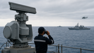
Maritime surveillance combines sensors, platforms and information systems to detect, track and identify vessels and activities at sea. It supports maritime domain awareness, navigation safety, law enforcement, environmental monitoring and national security across coastal waters and remote ocean areas.
Key Sensor Technologies
Sensors collect the observations used to build a picture of activity at sea. Their capabilities differ: radar and optical systems observe surface targets, while sonar detects objects underwater.
- Radar: Radio Detection and Ranging transmits electromagnetic waves and analyses their echoes to estimate an object’s range, angle or velocity. Surface-search radar detects ships and other large surface objects; navigation radar supports safe passage, while weather radar identifies atmospheric conditions.
- Radar uses: Radar supports vessel tracking, collision avoidance, coastal security and naval operations. It can operate in darkness and fog. Advanced techniques can detect beyond the line of sight, although this depends on the system and operating conditions.
- Sonar: Sound Navigation and Ranging uses sound waves underwater. Active sonar emits pulses and measures returning echoes to locate objects; passive sonar listens for sounds produced by targets, including submarines or marine life.
- Sonar uses: Sonar is important for anti-submarine warfare (ASW) and mine countermeasures (MCM). It is also used for bathymetry, fish finding, wreck location and diver detection.
- Electro-optical and infrared: Electro-optical (EO) sensors use visible light to produce high-resolution images for target identification. Infrared (IR) sensors detect heat signatures, helping locate objects in darkness or low light and through smoke or camouflage. Combined systems may use laser rangefinders to measure distance.
Aerial, Surface and Underwater Platforms
Surveillance equipment is carried by aircraft, ships and unmanned systems. Using different platforms extends coverage and provides observations from the air, sea surface and underwater.
- Maritime Patrol Aircraft: Fixed-wing aircraft conduct extended missions over water, including long-range reconnaissance, ASW, anti-surface warfare and search and rescue. Their equipment can include radar, sonar buoys, EO/IR cameras and Electronic Support Measures (ESM).
- P-8 Poseidon: The P-8 Poseidon is a United States Navy maritime patrol aircraft used for maritime patrol and reconnaissance.
- Unmanned Aerial Vehicles: UAVs or drones support persistent surveillance and intelligence gathering, including in high-risk areas. They reduce risk to personnel and may carry EO/IR cameras or small synthetic aperture radars (SAR).
- Naval vessels: Warships, patrol boats and coast guard vessels provide a direct presence for interception, data collection and enforcement of maritime laws. Their sensors can include surface radar, hull-mounted or towed sonar, and EO/IR systems.
- Autonomous Underwater Vehicles: AUVs are unmanned submersible robots used for covert data collection, seabed mapping, mine detection and environmental monitoring. Their sensors may include side-scan sonar, synthetic aperture sonar and environmental instruments.
Satellite and Coastal Surveillance
Space-based sensors provide wide-area coverage, including over remote maritime regions, while shore installations monitor coastal approaches and shipping lanes.
- Satellite imaging: Optical imagers collect visible-light data. Satellite-based SAR can image vessel movements by day or night and in all-weather conditions. Coverage and image detail depend on the satellite and its revisit time.
- Coastal radar: Fixed radar stations monitor coastal waters, shipping lanes and Exclusive Economic Zones (EEZs). They can track vessel movements and detect small boats near the coast, supporting coastal security and maritime traffic management.
Identification, Tracking and Data Integration
Surveillance systems must distinguish observed targets and combine information from multiple sources. Identification systems provide vessel reports, while data fusion helps operators compare those reports with radar, satellite and patrol observations.
- Automatic Identification System: AIS is a broadcast transceiver system required for internationally voyaging ships over 300 gross tonnage. Its transmitted information includes vessel identity, Maritime Mobile Service Identity (MMSI), position, course, speed, navigational status and cargo type.
- AIS purpose and limitation: AIS supports collision avoidance, traffic management and search-and-rescue coordination. A vessel can switch it off, and illicit operators may exploit this limitation; AIS data therefore does not provide a complete account of maritime activity.
- Long-Range Identification and Tracking: LRIT is an international system governed by the International Maritime Organization (IMO) for ships subject to the SOLAS Convention. Ships send position reports at regular intervals to flag and coastal states, supporting long-distance maritime awareness and security.
- Vessel Monitoring Systems: VMS primarily tracks fishing vessels by satellite. Fisheries authorities use it to monitor vessel movements and support compliance with fishing quotas and designated zones.
- Data fusion centres: These centres combine information from sources such as AIS, radar, satellites and air patrols. Correlation of reports helps form a unified operational picture and identify anomalies or potential threats.
Operational Value and Prelims Takeaways
A layered surveillance network improves maritime domain awareness by bringing together information from different sensors and platforms. Its effectiveness depends on reliable detection, identification and information sharing; a single system may have gaps, such as AIS signals that are switched off or satellite coverage limited by revisit time.
- Radar: Uses radio waves to detect and track surface objects; sonar uses sound waves to detect underwater objects.
- EO/IR: Visible-light imaging supports identification, while infrared sensors detect heat signatures.
- Platforms: Maritime patrol aircraft, UAVs, naval vessels and AUVs carry surveillance sensors for different operating environments.
- Satellites: Optical imaging and SAR support wide-area vessel monitoring; SAR works by day and night and in all-weather conditions.
- Tracking systems: AIS supports vessel identification and navigation, LRIT supports long-range ship tracking, and VMS primarily supports fisheries management.
- Black Sea and NATO: The Black Sea borders Bulgaria, Romania, Ukraine, Russia, Georgia and Türkiye. NATO was established on April 4, 1949, and has 32 members; its headquarters are in Brussels, Belgium.
Recent Context
On October 20, 2026, the North Atlantic Council discussed a response to drone strikes on commercial cargo vessels. NATO announced expanded Black Sea deployments; a US Navy P-8 Poseidon began reconnaissance patrols following a request from Sofia, confirmed by Bulgarian Prime Minister Rumen Radev.
| Related | |
|---|---|