Major High-Altitude Locations of India for Defence Operations
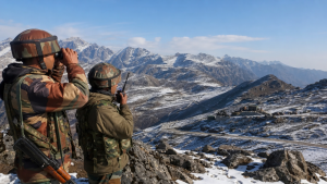
India’s high-altitude defence network spans the Himalayas and supports border security, logistics, air operations, and rapid troop movement in some of the world’s toughest terrain.
Strategic Context of High-Altitude Defence
Any military outpost situated above 9,000 feet is classified as a high-altitude area. India maintains one of the largest networks of high-altitude military bases in the world. These locations stretch across the union territory of Ladakh, Himachal Pradesh, Uttarakhand, Sikkim, and Arunachal Pradesh. They help secure India’s borders along the Line of Control (LoC) with Pakistan and the Line of Actual Control (LAC) with China. Operating in these terrains requires specialized training, custom equipment, and strong logistics infrastructure.
High-altitude defence depends on border infrastructure, terrain adaptation, and reliable logistics support.
Siachen Glacier: The Highest Battlefield on Earth
The Siachen Glacier is located in the eastern Karakoram Range of the Himalayas. It is widely recognized as the highest active battlefield on Earth.
- Altitude: The glacier extends from 18,000 feet to over 22,000 feet at the highest military posts.
- Geopolitical Value: Siachen acts as a wedge separating Pakistan-occupied Kashmir from China-occupied Aksai Chin.
- Key Defensive Posts: The Saltoro Ridge forms the actual ground position line. Key military posts include Indira Col, Kumar Post, and Bana Post.
- Extreme Weather: Temperatures can drop to minus 50 degrees Celsius. Soldiers face severe challenges like frostbite, avalanches, and low oxygen levels.
Advanced Landing Grounds in Eastern Ladakh
Advanced Landing Grounds (ALGs) are forward airfields that allow rapid deployment of troops, heavy weaponry, and essential supplies.
Daulat Beg Oldie
- Altitude: This airfield is located at an elevation of 16,700 feet.
- Position: Daulat Beg Oldie (DBO) sits in northern Ladakh, close to the Karakoram Pass.
- Defence Utility: It is the world’s highest active airstrip. The Indian Air Force regularly lands heavy transport aircraft, such as the C-130J Super Hercules, at this location. It provides direct support to troops guarding the Sub-Sector North.
Mudh-Nyoma Air Force Station
- Altitude: This airbase is situated at an altitude of approximately 13,700 feet.
- Position: It is located in southeastern Ladakh, just 23 kilometres from the LAC.
- Defence Utility: Originally, it operated as a basic landing strip. Recent development by the Border Roads Organisation has upgraded it into a full-fledged fighter airbase with a paved 3-kilometre runway. It can accommodate frontline fighter jets like the Rafale, Su-30MKI, and Tejas. This development drastically cuts down reaction times in the Eastern Ladakh sector.
Fukche Advanced Landing Ground
- Altitude: This landing ground is situated at an altitude of 13,700 feet.
- Position: It lies in the Demchok sector, only 2.5 kilometres away from the LAC.
- Defence Utility: Built before the 1962 war and revived in 2008, Fukche supports transport operations and tactical air movements near the Indus River.
Key Airbases and Logistics Hubs in Ladakh
A system of permanent bases provides continuous support to forward deployments.
Thoise Airbase
- Altitude: Located at an altitude of 10,062 feet in the Nubra Valley.
- Defence Utility: The name stands for Transit Halt of Indian Soldiers Enroute. It is the primary logistics hub enabling the movement of men and material to the Siachen Glacier. Heavy transport aircraft land here to deliver supplies, which are then moved to forward positions by helicopters and land transport.
Leh Air Force Station
- Altitude: This airbase is perched at 10,630 feet.
- Defence Utility: This is one of the highest military airfields in the world. It operates as a vital transport, logistics, and helicopter hub. It supports ground operations across Ladakh and maintains year-round connectivity when snow blocks high-altitude mountain passes.
Strategic Mountain Passes in the Eastern Sector
The eastern sector, primarily comprising Sikkim and Arunachal Pradesh, features critical high-altitude passes that require constant military vigil.
Sela Pass and the Sela Tunnel
- Altitude: Sela Pass sits at an altitude of 13,700 feet.
- Location: It lies on the boundary between West Kameng and Tawang districts in Arunachal Pradesh.
- Defence Utility: Heavy snowfall historically closed the pass during winter, disrupting supplies to the Tawang sector. The construction of the Sela Tunnel, the longest twin-lane tunnel above 13,000 feet in the world, ensures all-weather connectivity. It allows the army to move heavy artillery, armoured vehicles, and troops to the LAC without being observed by foreign forces.
Bum La Pass
- Altitude: Located at an altitude of 15,200 feet.
- Location: Situated north of Tawang on the Indo-China border.
- Defence Utility: This pass was a primary entry route during the 1962 war. Today, it serves as an active border post and one of the designated Border Personnel Meeting points between the Indian Army and the People’s Liberation Army of China.
Nathu La and Jelep La
- Altitude: Nathu La is at 14,140 feet, and Jelep La is at 13,999 feet.
- Location: These passes are located in the East Sikkim district.
- Defence Utility: They overlook the Chumbi Valley, a narrow wedge of Chinese territory between India and Bhutan. Nathu La serves as an important border trading post and an active military checkpoint, while Jelep La provides an alternative route to Lhasa.
Crucial Passes and Logistics Nodes in the Western and Central Sectors
Zoji La
- Altitude: Located at an elevation of 11,575 feet.
- Location: Connects Srinagar in the Kashmir Valley with Leh in Ladakh.
- Defence Utility: It is the primary land lifeline for the transport of military equipment and rations. The ongoing construction of the Zoji La Tunnel aims to bypass winter closures and provide continuous access.
Lipulekh Pass
- Altitude: Situated at 16,500 feet.
- Location: Located in the Pithoragarh district of Uttarakhand.
- Defence Utility: It sits at the tri-junction of India, China, and Nepal. It is an important post for trade, pilgrimage, and strategic border monitoring.
Comparative Overview of High-Altitude Defence Locations
| Location | State / Union Territory | Altitude (Feet) | Primary Military Function |
| Siachen Glacier | Ladakh | 18,000 – 22,000 | Active high-altitude battlefield, strategic wedge |
| Daulat Beg Oldie (DBO) | Ladakh | 16,700 | World’s highest active airstrip, rapid logistics |
| Mudh-Nyoma Airbase | Ladakh | 13,700 | Frontline fighter jet operations near Eastern LAC |
| Fukche ALG | Ladakh | 13,700 | Tactical landing ground in Demchok sector |
| Leh Air Force Station | Ladakh | 10,630 | Dual-use airfield, primary logistics hub for Ladakh |
| Thoise Airbase | Ladakh | 10,062 | Transit and logistics hub for Siachen operations |
| Sela Pass & Tunnel | Arunachal Pradesh | 13,700 | All-weather transit route to Tawang and Eastern LAC |
| Bum La Pass | Arunachal Pradesh | 15,200 | Border defence post, Border Personnel Meeting point |
| Nathu La Pass | Sikkim | 14,140 | Chumbi Valley monitoring, border trade point |
| Lipulekh Pass | Uttarakhand | 16,500 | Tri-junction border post, central sector monitoring |
Specialized Support Systems for Mountain Warfare
Operating in high-altitude environments requires unique logistics and tactical preparations.
Cold Mountain Warfare Specialization
India operates the High Altitude Warfare School (HAWS) in Gulmarg, Jammu and Kashmir. This institution trains Indian soldiers and friendly foreign armies in specialized high-altitude survival, snow-craft, and mountain warfare techniques. It is considered one of the premier military training centres globally for extreme environments.
The Ladakh Air Grid
The combination of Leh, Thoise, Kargil, Nyoma, Fukche, and Daulat Beg Oldie forms a highly connected network of airfields. This defensive network allows the Indian Air Force to distribute its assets. If one airfield faces a disruption, other stations can quickly cover the operations, creating a resilient backup system near the northern borders.
The Ladakh air network improves redundancy and ensures operational continuity during disruption, snowfall, or enemy observation.
Recent Context
The Defence Research and Development Organisation (DRDO) successfully conducted high-altitude trials of the indigenous Military Combat Parachute System (MCPS) from 22,000 feet. The system, developed by ADRDE, Agra, and DEBEL, Bengaluru, supports deployments above 25,000 feet and includes NavIC compatibility, oxygen support, and thermal jumpsuits.
Rare Facts for Prelims
- Indira Col: It is among the northernmost points of India and lies on the Siachen ridge system.
- Saltoro Ridge: Control over this ridge is strategically more important than control over the glacier bed below it.
- Thoise Airbase: Its full form is a useful exam fact: Transit Halt of Indian Soldiers Enroute.
- Chumbi Valley: The valley monitored from Nathu La forms a narrow wedge between India and Bhutan.
- Sela Tunnel: It is designed to reduce winter vulnerability in access to Tawang, a sensitive border region.
- HAWS, Gulmarg: This school is among the few institutions in the world focused entirely on high-altitude warfare training.
| Related | |
|---|---|