Types of Drought and Drought Assessment in India
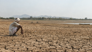
Drought develops when precipitation remains inadequate for a prolonged period, reducing water availability and affecting crops, livelihoods and essential services. Its effects vary with the part of the water cycle under stress, so assessment combines rainfall, soil moisture, crop and water-resource indicators.
Types of Drought
Drought categories reflect where moisture deficits occur, and conditions may progress from rainfall shortage to impacts on water supplies, crops and society.
- Meteorological drought: A significant shortfall in rainfall from the normal level over a specified area and period. The India Meteorological Department (IMD) typically uses a rainfall departure of 25% or more from normal to identify meteorological drought.
- Hydrological drought: A prolonged deficit that reduces water in rivers, lakes, reservoirs and groundwater. Low streamflow, falling reservoir storage and depleted groundwater tables are indicators.
- Agricultural drought: Inadequate soil moisture for crop growth, caused by low or poorly distributed rainfall or high evapotranspiration. It can lead to wilting, stunted growth and lower yields, affecting food security and farm incomes.
- Socio-economic drought: Water scarcity disrupts the supply of, or demand for, goods and services. Effects may include reduced agricultural income, industrial production and energy generation, as well as inadequate drinking water.
Drought Assessment in India
The Ministry of Agriculture and Farmers Welfare’s Manual for Drought Management guides states in assessing drought and making decisions on declaration and response. The assessment considers multiple indicators; rainfall deficit alone does not capture the effects on crops, water supplies or people.
- Rainfall monitoring: IMD rainfall data are examined at district and sub-district levels, including the percentage departure from normal. Rainfall distribution and the period over which the deficit occurs are relevant to assessing conditions.
- Sowing and crop condition: A reduction in area sown compared with normal can signal stress. Crop condition is assessed through ground reports, crop-cutting experiments and vegetation-health information.
- Soil-moisture adequacy: The Moisture Adequacy Index (MAI), derived from rainfall and potential evapotranspiration, indicates whether moisture is adequate for crop growth.
- Remote sensing: Satellite inputs from the National Remote Sensing Centre (NRSC) help identify vegetation stress and assess agricultural drought across wider areas. Vegetation indices such as NDVI can support this assessment.
- Water-resource status: Reservoir storage, river flows and groundwater depths help establish whether rainfall deficits have affected surface and subsurface supplies. The Central Water Commission (CWC) and state water-resource departments monitor relevant conditions.
- Ground verification: State authorities combine indicator data with field verification before preparing a memorandum for drought declaration. A taluka is a subdistrict administrative unit within a district.
Early warning depends on timely rainfall and water-status information, while preparedness requires officials to identify affected areas and likely needs before shortages intensify. Since indicators can vary between locations, combining remote sensing with field assessment supports a more complete picture of drought severity.
Institutions and Responsibilities
- India Meteorological Department: Provides rainfall data and forecasts used for monitoring and early warning of meteorological drought.
- Central Water Commission: Monitors major reservoirs and river basins, providing information relevant to hydrological drought.
- Ministry of Agriculture and Farmers Welfare: Nodal ministry for drought management, including policy, scheme implementation and coordination of relief measures.
- NDMA and SDMAs: The National Disaster Management Authority and State Disaster Management Authorities frame disaster-management policies and guidelines, including drought planning, under the Disaster Management Act, 2005.
- National Centre for Crop Forecasting: Uses remote sensing and other technologies for crop-yield forecasting and drought-impact assessment.
Mitigation and Preparedness
Drought management includes immediate relief as well as measures to reduce vulnerability and strengthen water security. Water conservation means saving or preserving water; water efficiency involves innovations that enable water to be used more efficiently.
- MGNREGA: The Mahatma Gandhi National Rural Employment Guarantee Act provides rural employment, including through water-conservation works during drought periods.
- PMFBY: The Pradhan Mantri Fasal Bima Yojana provides crop insurance against yield losses caused by natural calamities, including drought.
- Jal Shakti Abhiyan: A time-bound, mission-mode campaign for water conservation.
- National Food Security Mission: Seeks to increase food-grain production and strengthen food security.
- Local water works: Measures such as groundwater recharge, well deepening and desilting can support water availability. In Maharashtra, officials have been directed to undertake conservation works based on the Shirpur pattern.
- Preparedness priorities: Reliable early-warning systems, timely field surveys and coordinated district-level action help target relief and reduce the effects of drinking-water and fodder shortages.
Key Prelims Takeaways
- Drought types are meteorological, hydrological, agricultural and socio-economic.
- IMD monitors rainfall; CWC monitors major reservoirs and river basins.
- Drought assessment uses rainfall departure, sowing area, crop condition, MAI, vegetation indices and hydrological status.
- The Ministry of Agriculture and Farmers Welfare is the nodal ministry for drought management.
- The Manual for Drought Management guides state assessment and drought-related decisions.
- MGNREGA, PMFBY and Jal Shakti Abhiyan support employment, crop-risk coverage and water conservation respectively.
- A taluka is a subdistrict administrative unit; the Shirpur pattern is associated with groundwater-recharge works.
Recent Context
As of November 17, 2026, Maharashtra had declared 308 of its 358 talukas drought-affected; Chiplun, Wada, Vikramgad and Dindori were newly added. Assistance of ₹4,701.6 crore had been distributed to 94.3 lakh farmers, with the largest allocation going to Chhatrapati Sambhajinagar division.
| Related | |
|---|---|