Major Cyclone-Prone Basins of India
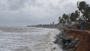
India’s long coastline makes it highly vulnerable to tropical cyclones in the North Indian Ocean. Two basins dominate cyclone formation here: the Bay of Bengal and the Arabian Sea, both of which influence regional disaster risk, coastal preparedness, and climate adaptation planning.
Understanding Tropical Cyclones
Tropical cyclones are rapidly rotating storm systems with a low-pressure center, spiral rainbands, heavy rainfall, and strong winds. They form over warm ocean waters and draw energy from the latent heat released during condensation. For development, conditions such as sea surface temperatures above 26.5°C, enough Coriolis force, low vertical wind shear, and a pre-existing disturbance are generally required.
The basic structure includes an eye, which is a relatively calm central region; an eyewall, where the most intense thunderstorms occur; and surrounding outer rainbands. In the North Indian Ocean, cyclone monitoring is especially important because storms often affect densely populated coasts, fishing zones, ports, agriculture, and urban infrastructure.
Why India’s Coasts Are Exposed
India’s coastal exposure is not uniform. The eastern seaboard, especially the Bay of Bengal side, faces more frequent and often more destructive cyclones, while the western coast is less frequently hit but still vulnerable to severe weather systems. Coastal risk is shaped by geography, sea-surface conditions, coastal shape, and population density.
- Storm surge risk: Low-lying coasts can face seawater inundation and flooding.
- Dense settlement: Large coastal populations increase the human and economic impact of landfalling storms.
- Livelihood vulnerability: Fishing, transport, ports, and coastal agriculture are directly affected.
- Preparedness challenge: Rapid intensification can reduce warning time and strain evacuation systems.
The Bay of Bengal Basin
The Bay of Bengal is the more active of the two major cyclone-forming basins. It accounts for roughly 75-80% of the tropical cyclones that affect the Indian coastline. Its warmer waters, funnel-shaped coastline, and freshwater inflow from major rivers such as the Ganges and Brahmaputra contribute to favorable conditions for cyclone formation.
Lower salinity due to freshwater inflow can help warm the surface layers more easily, supporting cyclogenesis. The basin is therefore a major focus of disaster management and early warning systems.
- Highly vulnerable states: Odisha, Andhra Pradesh, West Bengal, and Tamil Nadu.
- Union Territory exposed: Puducherry.
- Common impacts: Heavy rain, strong winds, storm surge, and widespread destruction.
- Peak periods: Post-monsoon (October-December) and pre-monsoon (April-May).
Historically, many of India’s most damaging cyclones have originated in this basin, making it central to coastal disaster preparedness and long-term climate adaptation strategies.
The Arabian Sea Basin
The Arabian Sea basin has traditionally produced fewer severe cyclones than the Bay of Bengal, but this pattern has shown change in recent decades. Rising sea surface temperatures are linked to an increase in both the frequency and intensity of tropical cyclones in this basin.
Although the number of storms is lower, their impact can still be severe because they can bring destructive winds, heavy rainfall, and coastal flooding to the western seaboard.
- Vulnerable states: Gujarat, Maharashtra, Goa, Karnataka, and Kerala.
- Important seasons: Pre-monsoon (May-June) and post-monsoon (October-November).
- Risk profile: Lower frequency than the Bay of Bengal, but increasing intensity is a concern.
- Policy relevance: Changing cyclone behavior strengthens the case for coastal adaptation and resilient infrastructure.
For exam purposes, it is important to note that the Arabian Sea is no longer considered low-risk in absolute terms. Recent trends underline the need for better forecasting and coastal planning on India’s western coast as well.
IMD and Cyclone Classification
The India Meteorological Department (IMD) is India’s national agency for weather forecasting and cyclone warnings. It also serves as one of the six Regional Specialized Meteorological Centres (RSMCs) globally and is designated for the North Indian Ocean, covering both the Bay of Bengal and the Arabian Sea.
IMD issues warnings and advisories for the region and supports 13 member countries. It classifies tropical weather systems according to maximum sustained wind speed.
| System | Wind speed |
| Low Pressure Area | Less than 31 km/h |
| Depression | 31-49 km/h |
| Deep Depression | 50-61 km/h |
| Cyclonic Storm | 62-88 km/h |
| Severe Cyclonic Storm (SCS) | 89-117 km/h |
| Very Severe Cyclonic Storm (VSCS) | 118-165 km/h |
| Extremely Severe Cyclonic Storm (ESCS) | 166-220 km/h |
| Super Cyclonic Storm (SuCS) | Above 220 km/h |
- Color-coded alerts: Yellow means be updated, Orange means be prepared, and Red means take action.
- Red alert: Issued for very severe weather conditions requiring immediate action by authorities and the public.
- Deep depression: Stronger than a depression but weaker than a cyclonic storm.
- Monitoring role: IMD tracks systems such as deep depressions under its cyclone warning framework.
Cyclone Naming in the North Indian Ocean
The cyclone naming system for the North Indian Ocean began in 2004. Naming is handled by RSMC New Delhi, which is the IMD. The naming list is prepared from contributions by 13 member countries: Bangladesh, India, Iran, Maldives, Myanmar, Oman, Pakistan, Qatar, Saudi Arabia, Sri Lanka, Thailand, United Arab Emirates, and Yemen.
Names are used sequentially from the common list. A weather system is named only when it reaches Cyclonic Storm intensity, with 3-minute sustained wind speeds of at least 63 km/h.
- Single-use names: Each name is used only once in the North Indian Ocean list.
- No retirement: Names are not retired in this basin.
- Current example: As of September 2026, “Arnab” was designated for the next cyclonic storm.
- Name meaning: “Arnab” means “ocean” in Bengali and was contributed by Bangladesh.
Key Prelims Takeaways
- Two major basins: The Bay of Bengal and the Arabian Sea are India’s main cyclone-forming basins.
- Higher Bay of Bengal risk: The Bay of Bengal produces a much larger share of cyclones affecting India.
- IMD role: The India Meteorological Department is the national agency for cyclone warnings and the RSMC for the North Indian Ocean.
- Deep depression: It is stronger than a depression but weaker than a cyclonic storm.
- Alert meaning: A red alert signals very severe weather and the need for immediate action.
- Naming threshold: Cyclones are named when they reach cyclonic storm intensity, with 3-minute sustained winds of at least 63 km/h.
- Eastern coast vulnerability: Visakhapatnam, Gopalpur, and Kalingapatnam are coastal locations on India’s eastern seaboard.
- Seasonality: The Bay of Bengal is active mainly in the post-monsoon and pre-monsoon periods.
- Western coast trend: The Arabian Sea is seeing increasing cyclone intensity in recent decades.
- Naming list: Thirteen countries contribute names, and each name is used only once.
Recent Context
A deep depression over the Bay of Bengal in September 2026 highlighted the continuing vulnerability of India’s eastern coast. Such systems are closely monitored by IMD because they can intensify quickly and affect north Andhra Pradesh and south Odisha coastlines with rain, wind, and coastal flooding risks.
| Related | |
|---|---|