Key Concepts in Floodplain and River Management
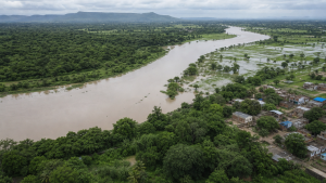
A river basin and its floodplain are closely linked to flood risk, land use, groundwater recharge, and ecosystem health. Effective river management combines engineering, planning, legal controls, and ecological protection.
Understanding Rivers and Floodplains
A river basin is the entire geographical area drained by a river and its tributaries. It is also called a catchment area or drainage basin. A floodplain is the flat or nearly flat land adjacent to a river that naturally floods when water spills over the banks.
Floodplains act as natural shock absorbers during heavy rainfall. They absorb excess water, slow the flow of the river, reduce downstream flooding, recharge groundwater, filter pollutants, and support rich riparian ecosystems.
Key Terms in River Hydrology
Understanding river management requires knowledge of basic hydrological terms that describe water movement, landform creation, and river-environment interaction.
- Run-off: The portion of precipitation that flows over the land surface into rivers and streams instead of soaking into the soil.
- Base Flow: The sustained flow of a river, fed mainly by groundwater during dry periods.
- Peak Flow: The maximum river discharge recorded during a flood event.
- Riparian Zone: The interface between land and a river or stream, usually supporting moisture-loving vegetation that stabilizes banks and filters runoff.
- Environmental Flows (E-flows): The minimum quantity, quality, and timing of water needed to sustain freshwater ecosystems and human livelihoods.
- Siltation: The accumulation of fine sand and clay particles in riverbeds, reducing carrying capacity and increasing flood risk.
- Meander and Oxbow Lake: A meander is a winding bend in a river; when erosion and deposition cut it off, a U-shaped oxbow lake is formed.
| Hydrological Concept | Primary Function or Feature |
| Catchment Basin | Collects all rainfall and funnels it into a single river system. |
| Natural Levee | A natural ridge formed by silt deposition along riverbanks during floods. |
| Estuary | The tidal mouth of a large river, where freshwater meets saltwater. |
| Delta | A landform created by deposition of sediment at the mouth of a river as it enters a slower-moving body of water. |
Structural versus Non-Structural Flood Management
Flood management strategies are broadly divided into structural and non-structural measures. Governments usually combine both to reduce flood losses and improve resilience.
Structural Measures
These involve physical engineering works to control, redirect, or contain water flows.
- Embankments and Dykes: Artificial walls constructed along riverbanks to prevent water from spilling into adjacent lowlands.
- Dams and Reservoirs: Large structures built across rivers to store excess water during peak flows and release it gradually.
- Channel Improvement: Widening, deepening, or straightening river channels to increase flow capacity.
- Bypass Channels: Artificial canals that divert excess water away from vulnerable urban areas back into the main river or another downstream water body.
Non-Structural Measures
These focus on keeping people and property away from floodwaters rather than controlling the water itself.
- Floodplain Zoning: Regulating land-use activities on floodplains based on flood risk.
- Flood Forecasting and Early Warning: Using meteorological data and river gauges to predict floods and warn populations in advance.
- Catchment Area Treatment: Afforestation and soil conservation in upper catchments to reduce soil erosion and run-off.
- Disaster Preparedness: Developing evacuation plans, constructing flood shelters, and training communities.
| Management Type | Key Interventions | Main Advantages | Chief Challenges |
| Structural | Reservoirs, embankments, channelization | Direct protection of specific regions | High capital cost, downstream siltation, potential catastrophic failure |
| Non-Structural | Zoning, forecasting, insurance | Lower costs, ecological preservation, long-term safety | Needs strict enforcement, difficult in densely populated regions |
The Concept of Floodplain Zoning
Floodplain zoning is a land-use planning strategy that designates areas along rivers for different uses based on flood frequency. It helps prevent high-value development in high-risk zones.
The National Disaster Management Authority (NDMA) outlines zones according to flood recurrence.
- 10-Year Flood Frequency Zone: This area has a 10% chance of flooding in any given year. It should remain free of concrete structures. Permissible uses include parks, playgrounds, gardens, and pastures.
- 25-Year Flood Frequency Zone: This area has a 4% annual chance of flooding. It is suitable for regulated agricultural activities, temporary structures, and recreational facilities.
- 100-Year Flood Frequency Zone: This area has a 1% annual chance of flooding. Critical public infrastructure such as hospitals, electrical substations, water treatment plants, and emergency response centres must be located above this level or protected by walls.
Flood risk mapping and floodplain zoning are important tools for land-use regulation and disaster resilience.
Legal and Institutional Framework in India
India is highly vulnerable to floods, with around 40 million hectares of land classified as flood-prone. Managing these areas requires legal powers, policy tools, and institutional coordination.
Constitutional Provisions
Under the Seventh Schedule of the Constitution of India, water management is divided as follows:
- State List (List II): Entry 17 covers water supply, irrigation, canals, drainage, embankments, and water storage. Entry 18 covers land. This makes floodplain zoning and flood management primarily a state responsibility.
- Union List (List I): Entry 56 covers regulation and development of inter-state rivers and river valleys to the extent declared by Parliament.
Key Policies and Legislation
- Model Flood Plain Zoning Bill, 1975: Circulated by the Central Water Commission (CWC) to help states enact floodplain zoning laws. It provides for a Flood Plain Zoning Authority. Only a few states, including Manipur, Rajasthan, Uttarakhand, and Jammu & Kashmir, have enacted laws based on this model.
- National Green Tribunal (NGT) Directives: The NGT has issued orders creating no-construction zones along rivers. In some vulnerable stretches, it has mandated a 500-metre buffer from the central lining of major rivers.
- River Ganga Authorities Order, 2016: This order bans construction on the active floodplain of the River Ganga and its tributaries to preserve ecological integrity.
- Dam Safety Act, 2021: Provides a national framework for surveillance, inspection, operation, and maintenance of specified dams to prevent dam-failure disasters.
Central Institutional Bodies
- Central Water Commission (CWC): The premier technical organisation under the Ministry of Jal Shakti. It handles flood forecasting, compiles hydrological data, and advises states on water resources schemes.
- Ganga Flood Control Commission (GFCC): Created in 1972 to prepare comprehensive plans for flood control in the Ganga Basin states.
- Brahmaputra Board: A statutory body established under the Brahmaputra Board Act, 1980. It manages flood control, bank erosion, and drainage in the Brahmaputra and Barak valleys.
- National Mission for Clean Ganga (NMCG): Coordinates efforts to prevent pollution and rejuvenate the Ganga river basin.
Ecological Dimensions of River Management
Modern river management emphasises ecological health along with flood control.
- River Rejuvenation: The process of restoring a river’s self-cleaning capacity, water quality, and natural flow. It involves stopping sewage inflow, reviving riparian vegetation, and removing encroachments.
- Desiltation and Dredging: Periodic removal of accumulated silt from the riverbed. Siltation raises the riverbed and lowers water-carrying capacity, but excessive dredging can damage ecosystems and destabilise bridge foundations.
- Wetland Restoration: Wetlands act as natural sponges. Restoring connected wetlands helps store excess water during monsoon peaks, reduce river discharge, and recharge regional aquifers.
Recent Context
In a suo motu environmental case on the Jojari River, the Supreme Court ordered interim restrictions on construction and hazardous activities near the river until scientific demarcation of the high flood line and ecological buffers is completed.
Rare Facts for Prelims
- High Flood Line (HFL): It marks the highest scientifically determined level reached by floodwaters in a region.
- Natural levees often form because coarser sediment settles first when floodwater overflows the banks.
- Oxbow lakes are most common in mature floodplains where meanders become highly curved over time.
- Riparian vegetation helps reduce bank erosion by binding soil with roots and slowing surface runoff.
- Catchment treatment in upper basins can reduce both soil loss and downstream flood peaks.
- Environmental flows are important not only for biodiversity but also for maintaining fisheries and water quality.
| Related | |
|---|---|