India–Nepal Border Management Agencies and Laws
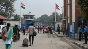
India and Nepal share a long, open border governed by old treaties, bilateral understanding, and coordinated border management. The frontier allows visa-free and passport-free movement for citizens of both countries while security and customs agencies monitor trade, migration, and cross-border crime.
Historical Treaties and Legal Framework
The legal basis of the India–Nepal boundary comes mainly from the Treaty of Sagauli (1816) and the India–Nepal Treaty of Peace and Friendship (1950). These arrangements shaped the boundary line, border mobility, and the broad framework of bilateral relations.
- Treaty of Sagauli: Signed on December 2, 1815, and ratified on March 4, 1816, it ended the Anglo-Nepalese War between the British East India Company and the Kingdom of Nepal.
- Boundary alignment: The treaty fixed the Kali (Mahakali) River as the western boundary and the Mechi River as the eastern boundary.
- Territorial changes: Nepal ceded territories west of the Kali River, including Kumaon and Garhwal, parts of the Terai plains, and regions between the Mechi and Teesta rivers.
- Treaty of Peace and Friendship (1950): Signed in Kathmandu on July 31, 1950, it remains central to the open-border regime.
- Article 6: Provides national treatment to citizens of each country in relation to industrial and economic development.
- Article 7: Grants reciprocal rights regarding residence, property ownership, trade and commerce, and free movement across the border without travel visas.
Border Profile and State-Wise Spread
The India–Nepal boundary is open and extends across five Indian states. Bihar shares the longest stretch, followed by Uttar Pradesh and Uttarakhand. The border touches more than 20 Indian districts and supports a dense network of local movement, trade routes, and customs posts.
| Indian State | Border Length | Bordering Districts |
| Bihar | 726 km | West Champaran, East Champaran, Sitamarhi, Madhubani, Supaul, Araria, Kishanganj |
| Uttar Pradesh | 551 km | Pilibhit, Lakhimpur Kheri, Bahraich, Shravasti, Balrampur, Siddharthnagar, Maharajganj |
| Uttarakhand | 275 km | Pithoragarh, Champawat, Udham Singh Nagar |
| West Bengal | 100 km | Darjeeling, Kalimpong, North Dinajpur |
| Sikkim | 99 km | West Sikkim, North Sikkim |
| Total | 1,751 km | 20+ districts |
Boundary Management Mechanisms
Border demarcation and maintenance are handled through bilateral technical and working arrangements. These mechanisms focus on border pillars, strip maps, encroachments, and disputed stretches rather than routine immigration control, since the border remains open.
- Joint Technical Level Boundary Committee: Worked from 1981 to 2007 to identify border pillars and prepare strip maps covering roughly 98 percent of the boundary.
- Boundary Working Group (BWG): Established in 2014 to oversee construction, restoration, and maintenance of border pillars.
- No Man’s Land: The BWG also deals with encroachments in the border strip area referred to as No Man’s Land.
- Border pillars: Their construction, repair, and verification are important for keeping the boundary line clear and mutually recognized.
- Strip maps: These remain important reference documents for technical boundary work.
Integrated Check Posts and Trade Corridors
The Land Ports Authority of India (LPAI) develops and manages Integrated Check Posts (ICPs) on the India–Nepal border. These facilities streamline trade, customs clearance, and passenger movement while supporting lawful cross-border commerce.
- ICP Raxaul–Birgunj: Handles the largest share of bilateral trade and cargo transit.
- ICP Jogbani–Biratnagar: Serves eastern Nepal and the industrial zones in Morang district.
- ICP Rupaidiha–Nepalgunj: Connects western Nepal with Indian supply chains.
- ICP Banbasa–Kanchanpur: Facilitates transit in the far-western sector of Nepal.
- Jaynagar–Kurtha railway: Cross-border rail connectivity operates on this broad-gauge route.
- Trade facilitation: ICPs help regulate cargo, passenger movement, and customs procedures more efficiently.
Security Agencies and Border Governance
Security on the India–Nepal frontier is based on coordinated enforcement rather than a sealed border. The system combines border guarding, customs control, intelligence inputs, and cooperation with Nepalese agencies.
- Sashastra Seema Bal (SSB): The designated Lead Intelligence Agency and primary border guarding force for the India–Nepal border.
- Administrative control: The SSB functions as a Central Armed Police Force under the Ministry of Home Affairs.
- Deployment: It has been deployed on the India–Nepal border since 2001.
- Border Outposts (BOPs): The SSB uses BOPs to prevent trans-border crime, arms smuggling, narcotics trafficking, human trafficking, and fake currency circulation.
- Soft border doctrine: The force follows a soft border approach that allows genuine local movement while checking illegal activity.
- APF of Nepal: The Armed Police Force of Nepal is the primary counterpart to the SSB on the Nepalese side.
- CBIC: The Central Board of Indirect Taxes and Customs operates Land Customs Stations to regulate lawful commercial cargo and enforce customs laws.
- NCB and DRI: These agencies coordinate with state police in bordering states to counter narcotics flows and contraband.
Disputed and Sensitive Sectors
Most of the border is peaceful, but a few sectors remain sensitive because of river shifts, map interpretations, and competing claims over historical boundary lines.
- Kalapani–Limpiyadhura–Lipulekh sector: The dispute concerns the source of the Kali River, which forms the boundary under the Treaty of Sagauli.
- India’s position: India treats the main stream originating near Kalapani or the Lipulekh pass as the traditional border, placing the area in Pithoragarh district, Uttarakhand.
- Nepal’s position: Nepal claims the river originates further west from the Limpiyadhura ridgeline and asserts sovereignty over the triangular territory.
- Lipulekh pass: Serves as a designated trade and pilgrimage route for the Kailash Mansarovar Yatra.
- Susta sector: Located on the eastern bank of the Gandak River, adjacent to West Champaran district in Bihar.
- Cause of dispute: The Gandak River’s course has shifted over time, leaving land that once lay on one bank on the opposite side.
Key Prelims Takeaways
- Open border: India and Nepal allow passport-free and visa-free movement for citizens of both countries.
- Total boundary: The international border is 1,751 km long.
- Longest state stretch: Bihar shares the longest border with Nepal at 726 km.
- Five border states: Uttarakhand, Uttar Pradesh, Bihar, West Bengal, and Sikkim.
- Treaty of Sagauli: Established the Kali River as the western boundary and the Mechi River as the eastern boundary.
- SSB role: The Sashastra Seema Bal is the main border guarding force for the India–Nepal frontier.
- Border management: The BWG handles border pillars, maintenance, and encroachments in No Man’s Land.
Exam fact: The SSB was originally raised in 1963 as the Special Service Bureau and was designated the specialised border guarding force for the India–Nepal border in June 2001.
| Related | |
|---|---|