Major Peatlands of the World
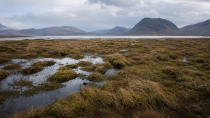
Peatlands are waterlogged terrestrial wetlands where partially decayed plant matter accumulates slowly under oxygen-poor conditions. The resulting peat is a carbon-rich soil that forms in mires, bogs, fens and peat swamps. Although peatlands cover only about 3% of the global land surface, they are among the world’s most important carbon stores and play a major role in climate regulation.
Why Peatlands Matter
- Huge carbon stock: Pristine peatlands store about 550 to 600 gigatonnes of carbon globally, more than all the world’s forest biomass combined.
- Annual sequestration: Healthy peatlands sequester around 0.096 petagrams of carbon annually.
- Climate role: They act as long-term carbon sinks when waterlogged and undisturbed.
- Emissions when degraded: Drained peatlands turn into sources of carbon dioxide and contribute nearly 4% to 5% of global anthropogenic greenhouse gas emissions, excluding fires.
- Wetland status: Peatlands are found in over half of all designated Ramsar sites worldwide, but only 17% of global peatlands are officially protected.
Major Peatlands of the World
| Peatland complex | Location | Approximate carbon stock | Key feature |
| West Siberian Lowland | Russia (Siberia) | 70 to 70.2 gigatonnes | Largest high-latitude wetland; dominated by boreal bogs |
| Hudson Bay Lowlands | Canada (Ontario, Manitoba, Quebec) | 30 to 39 gigatonnes | Continuous permafrost; often described as the “breathing lands” |
| Cuvette Centrale | DR Congo and Republic of Congo | 30 to 30.6 gigatonnes | Largest tropical peat complex; mapped in 2017 |
| Southeast Asian Peatlands | Indonesia (Sumatra, Kalimantan, Papua) | 28 to 30 gigatonnes | Tropical peat swamp forests, much of them drained |
| Pastaza-Marañón Basin | Peru (Western Amazon Basin) | 3.1 to 3.14 gigatonnes | Largest Amazonian peat complex; palm swamps |
Tropical Peatland Complexes: Congo and Amazon Basins
- Cuvette Centrale: This transboundary peatland spans about 145,000 square kilometres across the Democratic Republic of Congo and the Republic of Congo.
- Carbon significance: It holds nearly 28% of the global tropical peat carbon pool and is equivalent to roughly three years of global fossil fuel emissions.
- Threats: Logging, agricultural expansion, and oil and gas concessions pose major risks to this carbon-dense landscape.
- Pastaza-Marañón Basin (PMFB): Located in northwestern Peru, the PMFB covers about 35,000 to 36,000 square kilometres and is the largest tropical peatland complex in the Amazon Basin.
- Vegetation: These peatlands are dominated by palm swamp forests, especially the aguaje palm (Mauritia flexuosa).
- Climate sensitivity: Warming temperatures can weaken this sink and turn it into a carbon source.
Boreal and High-Latitude Peatlands: Russia and Canada
- West Siberian Lowland: This region stores over 70 billion tonnes of carbon and represents the world’s largest high-latitude peatland pool.
- Permafrost risk: Rapid Arctic warming threatens this reservoir by accelerating permafrost thaw.
- Dissolved organic carbon (DOC): Thawing Siberian peatlands release large amounts of DOC into Arctic rivers, affecting the biogeochemical cycle of the Arctic Ocean.
- Hudson Bay Lowlands: Spanning about 124,000 square miles in northern Canada, this is the second-largest peatland complex globally.
- Ecological importance: It hosts North America’s lowest-latitude continuous permafrost and provides habitat for polar bears and caribou.
- Industrial pressure: These peatlands face disturbance from mining in northern Ontario’s Ring of Fire region and from oil sands extraction in Alberta.
Peat Fires, Emissions and Monitoring
- Subsurface burning: Dry peat fires burn below the surface, smouldering for long periods and releasing toxic smoke.
- Health hazard: Smoke from peat fires contains fine particulate matter and harmful gases that affect respiratory health.
- Detection challenge: Thick forest canopies and heavy smoke can obscure underground smouldering, making peat fires difficult to detect fully through satellites.
- Monitoring tools: NASA’s Aqua satellite uses MODIS sensors to detect thermal anomalies and smoke plumes from active fires.
- Regional surveillance: The ASEAN Specialized Meteorological Centre in Singapore tracks fire activity across Southeast Asia.
- Global initiative: The United Nations Environment Programme (UNEP)-led Global Peatlands Initiative aims to conserve peatlands as the world’s largest terrestrial organic carbon stock.
Key Prelims Takeaways
- Carbon-rich soil: Peat forms from partially decomposed plant material in waterlogged conditions.
- Key ecosystem types: Active peat-accumulating wetlands are called mires, bogs, fens and peat swamps.
- Carbon density: Peatlands store far more carbon per unit area than dry tropical forests.
- Sphagnum moss: This moss genus is a major peat-former in boreal peatlands and helps retain water like a sponge.
- Methane risk: Flooded or thawing peatlands can release methane, a much stronger warming gas than carbon dioxide over a 100-year period.
- Global spread: Peatlands occur on every continent, from sub-polar bogs to tropical swamp forests.
- Ramsar relevance: Their presence in many Ramsar sites makes peatlands important for wetland conservation and climate resilience.
Recent Context
Indonesia’s peat fires intensified across Kalimantan and Sumatra in 2026 amid El Niño-driven drought, rising temperatures and widespread peat degradation. Heavy smoke, underground burning and limited rainfall made control difficult, while satellite monitoring showed a sharp rise in hotspots and greenhouse gas emissions.
Current General Studies comprises current-affairs-based, General Studies-rich study material on policies, laws, institutions, economy, science, environment, governance, international relations, and other varied but important topics for UPSC and State PSC Prelims examinations.
Fortnightly PDF compilations: Available here
Originally written on
September 6, 2026
and last modified on
September 6, 2026.
| Related | |
|---|---|