Major Earthquake-Prone Regions of the World
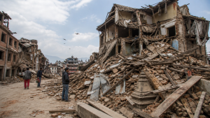
An earthquake is the sudden shaking of the Earth’s surface caused by the rapid release of energy along tectonic plate boundaries. Most major earthquakes occur in a few well-defined seismic belts and fault zones around the world.
Understanding Earthquake Mechanisms
An earthquake occurs when tectonic plates move and release stored energy in the lithosphere. The point of origin deep inside the Earth is called the hypocenter or focus, while the point directly above it on the surface is the epicenter.
Energy released during an earthquake travels through the ground as seismic waves. Seismographs record these waves to determine the magnitude and intensity of the quake. The Richter scale measures magnitude, while the Modified Mercalli scale measures observed damage at a specific location.
Major Seismic Belts of the World
Earthquakes are not distributed randomly across the globe. Most seismic activity is concentrated in distinct zones called seismic belts.
| Seismic Belt | Percentage of Global Earthquakes | Plate Boundary Type | Key Geographical Regions |
| Circum-Pacific Belt (Ring of Fire) | ~90% of all quakes (~81% of major quakes) | Convergent (Subduction) and Transform | Andes, West Coast of North America, Aleutian Islands, Japan, Philippines, Indonesia, New Zealand |
| Alpide Belt (Mid-Continental Belt) | ~17% of major quakes | Convergent (Continental Collision) | Mediterranean, Turkey, Caucasus, Himalayas, Myanmar, Sumatra |
| Mid-Atlantic Ridge | ~2% of all quakes | Divergent (Spreading Center) | Atlantic Ocean Floor, Iceland |
The Circum-Pacific Belt (Ring of Fire)
The Circum-Pacific Belt is the most active seismic zone on Earth. It forms a horseshoe shape stretching around the rim of the Pacific Ocean for about 40,000 kilometers.
Geological Mechanism
This belt lies along convergent plate boundaries. Oceanic plates such as the Pacific Plate, Nazca Plate, and Cocos Plate sink beneath adjacent continental or island arc plates. This process is called subduction. Friction and pressure from subducting plates generate deep, high-magnitude earthquakes.
Key Geomorphic Features and Regions
- Oceanic Trenches: Deep trenches like the Mariana Trench, Peru-Chile Trench, and Aleutian Trench mark the boundaries where subduction occurs.
- Volcanic Arcs: Volcanic chains like the Cascade Range in North America and the Andes in South America run parallel to these trenches. The Ring of Fire contains over 75% of the world’s active and dormant volcanoes.
- Active Island Arcs: The Japanese Archipelago, Kuril Islands, and Philippines form highly active island systems along the western edge of the belt.
Historic Seismic Events
- 1960 Valdivia Earthquake: A magnitude 9.5 earthquake struck Chile, marking the strongest recorded earthquake in history.
- 1964 Great Alaskan Earthquake: A magnitude 9.2 event shook southern Alaska and caused extensive tsunamis.
- 2011 Tohoku Earthquake: A magnitude 9.0 earthquake off the coast of Japan triggered a devastating tsunami.
The Alpide Belt (Mid-Continental Belt)
The Alpide Belt is the second most seismically active region. It extends from the Atlantic Ocean through the Mediterranean Sea, across Asia, and joins the Circum-Pacific Belt in the East Indies.
Geological Mechanism
Unlike the subduction-dominated Ring of Fire, this belt features massive continental collisions. The African, Arabian, and Indian plates collide with the Eurasian Plate. This ongoing collision pushes up major mountain ranges and results in frequent shallow and highly destructive earthquakes.
Key Regions and Fault Lines
- The Mediterranean Basin: Strong earthquakes occur across Italy, Greece, and the Balkans due to complex plate interactions between Europe and Africa.
- The Anatolian Plate: Turkey sits on this small plate, sandwiched between the Eurasian, Arabian, and African plates. The North Anatolian Fault is a highly active strike-slip fault crossing northern Turkey.
- The Himalayan Zone: The collision of the Indian Plate with the Eurasian Plate causes shallow, high-magnitude earthquakes in northern India, Nepal, Bhutan, and Pakistan.
- Southeast Asia: The belt continues through Myanmar and Sumatra, where it transitions back into a subduction zone.
The Mid-Atlantic Ridge Belt
The Mid-Atlantic Ridge is a giant underwater mountain range that runs down the center of the Atlantic Ocean, separating the North and South American plates from the Eurasian and African plates.
Geological Mechanism
This belt is a divergent boundary where plates pull apart from each other. New magma rises from the mantle, cools, and forms new oceanic crust. This process is known as seafloor spreading.
Key Features
- Focal Depth: Earthquakes along this ridge are almost exclusively shallow-focus, occurring near the surface of the oceanic crust.
- Moderate Magnitude: Most earthquakes are small to moderate and cause little direct threat because they occur deep underwater.
- Iceland: Iceland is a portion of the Mid-Atlantic Ridge that rises above sea level. It experiences both active volcanism and frequent seismic swarms due to its position directly on the divergent boundary.
Other High-Risk Localized Fault Zones
Outside the three main belts, several specific fault lines and rift systems experience frequent earthquakes.
San Andreas Fault Zone
- Location: California, United States.
- Plate Boundary: Transform boundary where the Pacific Plate and the North American Plate slide past each other horizontally.
- Seismic Hazard: Produces frequent shallow earthquakes, including the famous 1906 San Francisco earthquake.
East African Rift System
- Location: East Africa, stretching from the Red Sea to Mozambique.
- Plate Boundary: Developing divergent boundary where the African Plate is splitting into the Nubian and Somalian sub-plates.
- Seismic Hazard: Crustal extension causes shallow earthquakes and active volcanic activity, such as Mount Kilimanjaro and Mount Nyiragongo.
East Asian Intraplate Zones
- Location: Mainland China and Mongolia.
- Mechanism: Though far from active plate boundaries, compressive forces from the Himalayan collision transfer deep into the continental crust, causing devastating intraplate earthquakes.
Classification of Earthquakes by Depth
The depth of the focus determines the nature of seismic waves reaching the surface. Geologists divide earthquakes into three main depth categories.
Shallow-Focus Earthquakes
- Depth Range: 0 to 70 kilometers.
- Occurrence: These are the most common earthquakes, happening along all plate boundaries.
- Impact: They cause the most severe destruction because the seismic energy has less distance to travel before reaching the surface.
Intermediate-Focus Earthquakes
- Depth Range: 70 to 300 kilometers.
- Occurrence: These occur primarily in subduction zones where the sinking oceanic slab enters the upper mantle.
Deep-Focus Earthquakes
- Depth Range: 300 to 700 kilometers.
- Occurrence: These occur deep within the mantle, along the cold, subducting slab in the Wadati-Benioff zone.
- Impact: They rarely cause damage at the surface but are recorded globally by sensitive instruments.
Tectonic Boundary Classifications and Seismic Profiles
This table links the types of plate boundaries to their typical earthquake profiles.
| Plate Boundary | Geological Process | Typical Focal Depth | Maximum Magnitude Potential | Example |
| Convergent (Subduction) | One plate sinks beneath another | Shallow to Deep (up to 700 km) | Extremely High (Megathrust, M9+) | Chile Trench, Japan Trench |
| Convergent (Collision) | Two continental plates collide | Shallow to Intermediate | High (M7.5 to M8.5) | Himalayas |
| Divergent | Plates pull apart | Shallow (under 30 km) | Moderate (usually under M6.5) | Mid-Atlantic Ridge |
| Transform | Plates slide past horizontally | Shallow (under 25 km) | High (M7 to M8) | San Andreas Fault |
Recent Context
A 7.7-magnitude shallow earthquake struck off Flores Island, Indonesia, on 15 August 2026. BMKG issued a tsunami warning, later lifted after tide gauges showed limited wave changes.
Rare Facts for Prelims
- The Ring of Fire is not a continuous volcanic chain, but a belt of plate boundaries around the Pacific Ocean.
- Wadati-Benioff zones trace the descending slab in subduction zones and help map earthquake depth patterns.
- Iceland is one of the few places where the Mid-Atlantic Ridge is visible above sea level.
- Transform faults usually do not create or destroy crust, but they can still produce very damaging earthquakes.
- Shallow earthquakes are generally more destructive than deeper ones because seismic energy reaches the surface with less attenuation.
- Intraplate earthquakes can occur far from plate boundaries when old faults are reactivated by distant tectonic stresses.
| Related | |
|---|---|