Key Indicators of Glacier Change
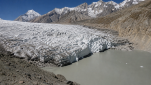
Glacier change is one of the clearest indicators of climate variability and long-term warming. Scientists track it through changes in ice gain or loss, glacier size, thickness, length, and meltwater output. These measures help assess climate trends, water availability, and hazards such as glacial lake outburst floods.
Glacier Mass Balance
Glacier mass balance is the most important measure of glacier health. It shows whether a glacier is gaining ice through snowfall and refreezing, or losing ice through melting and sublimation over a given period.
- Accumulation zone: Upper part of the glacier where snowfall adds more mass than is lost.
- Ablation zone: Lower part where ice loss from melt and sublimation exceeds snow accumulation.
- Equilibrium Line Altitude (ELA): The height where accumulation equals ablation. A rising ELA usually signals warmer conditions and stronger melt.
- Direct glaciological method: Measures snow depth, snow density, and surface lowering at stakes placed in the ablation zone.
- Geodetic method: Uses repeat elevation data from aerial photography, satellite altimetry, or airborne laser scanning to estimate volume changes.
- Gravimetry: Satellite missions such as GRACE detect changes in Earth’s gravitational field caused by ice-mass variation.
Mass balance is widely used because it links glacier behaviour directly to climate conditions. A negative balance over several years indicates persistent shrinkage, while a positive balance suggests glacier growth. For exam purposes, it is the standard scientific indicator of ice gain or loss and a key tool for climate trend analysis.
Glacier Volume and Thickness Change
Changes in glacier volume and thickness are direct signs of retreat. When a glacier loses mass over time, its surface lowers, its ice body thins, and its total volume declines.
- Thickness monitoring: Done through field surveys, aerial observations, and remote sensing.
- Volume loss: Shows the overall reduction in stored ice and is closely tied to negative mass balance.
- Surface lowering: Helps identify how fast a glacier is thinning in specific zones.
- Ice tongues: Lower glacier reaches often experience the fastest melting and can thin sharply in warm years.
- Swiss example: Between the 2025 and 2026 seasons, glacier ice volume in Switzerland shrank by 5.5%.
- Average thinning: Glacier thickness across Switzerland decreased by about 2.5 to 4 metres in 2026.
- Local losses: Some glacier tongues lost up to 10 metres of ice in 2026.
- Long-term decline: Nearly 20% of Switzerland’s total glacier volume vanished in the five years ending in 2026.
Volume and thickness changes are important because they reveal the physical scale of glacier loss. They also matter for downstream water supply, as thinner glaciers store less ice for summer melt. These indicators are especially useful where direct mass-balance data are limited.
Glacier Length and Area Change
Glacier retreat or advance can be seen at the terminus, or snout, and through changes in surface area. These visible changes are among the easiest indicators to observe in field and satellite studies.
- Terminus position: The lowest end of a glacier; its movement records advance or retreat.
- Area mapping: Satellite imagery and aerial photographs are used to measure changes in glacier outlines.
- Retreat: A shrinking glacier front generally reflects sustained warming or reduced snowfall.
- Advance: Can occur during cooler or snow-rich periods, though it is less common in a warming climate.
- Glacier count in Switzerland: The country has about 1,400 glaciers, mostly in the Alps.
- Largest glacier: The Aletsch Glacier is Switzerland’s largest by area and ice volume, and it lies in the Bernese Alps.
- Disappearances: Several smaller glaciers, including Bella Tola in Valais and Griessfirn in Glarus, disappeared completely in 2026.
Length and area changes are useful because they can be tracked over long periods and compared across regions. They also provide a clear visual record of glacier response to climate change, making them valuable in prelims-oriented revision.
Meltwater Runoff and Glacial Lake Outburst Floods
Glacier melt changes the amount and timing of water flowing downstream. It also contributes to the formation of glacial lakes, which can become hazardous if unstable natural dams fail.
- Runoff monitoring: Measures the volume of water discharged from glaciers and helps estimate ice-loss rates.
- Seasonal melt: Higher meltwater flow during warm months often signals intense glacier loss.
- Glacial lakes: Form when meltwater accumulates in front of or beside retreating glaciers.
- GLOF risk: Rapid lake expansion can trigger sudden and destructive floods if the dam fails.
- Disaster relevance: These floods are important for hazard mapping, early warning, and disaster risk reduction.
- Swiss melt signal: Melt during May to September 2026 released about 2.2 trillion litres of water from Swiss glaciers.
Glacial lake outburst floods are a major hazard linked to rapid glacier retreat and unstable natural dams.
Runoff and lake changes are especially significant in mountain regions because they affect drinking water, hydropower, irrigation, and flood risk. In a warming climate, these indicators help connect glacier change with both environmental and safety concerns.
Cryosphere and Monitoring Initiatives
Glaciers are part of the cryosphere, the frozen component of the Earth system. Monitoring glacier change therefore also helps understand wider changes in snow, ice, and permafrost across mountain regions.
- Cryosphere: Includes snow, glaciers, ice sheets, sea ice, lake ice, river ice, and permafrost.
- Alpine cryosphere: Refers to frozen components in mountain regions, including Swiss glaciers.
- GLAMOS: Glacier Monitoring in Switzerland, the national service tracking glacier mass balance, length change, and ice volume.
- Director: Matthias Huss serves as the director of GLAMOS.
- Monitoring record: GLAMOS has recorded successive extreme melt years since 2022.
- Global coordination: The Global Glacier Monitoring Service works under the World Glacier Monitoring Service (WGMS) to collect standardized glacier data.
Such monitoring systems are essential for comparing glacier trends across countries and decades. They support scientific assessment, climate analysis, and planning for water resources and mountain hazards.
Key Prelims Takeaways
- Glacier mass balance is the standard measure of ice gain or loss.
- Equilibrium Line Altitude (ELA) rises with warming and stronger melt.
- Glacier thickness and volume are measured using field surveys, aerial observations, and remote sensing.
- Glacier terminus movement and area mapping help track advance or retreat.
- Switzerland has about 1,400 glaciers, mostly in the Alps.
- Aletsch Glacier is Switzerland’s largest glacier by area and ice volume.
- GLAMOS is the Swiss national service for glacier monitoring; Matthias Huss is its director.
Recent Context
Switzerland’s glaciers lost over 5% of their total ice volume in 2026 after a winter with very little snow and a summer of record heatwaves. The Aletsch Glacier, along with the Rhône and Clariden glaciers, recorded exceptional melt, while several smaller glaciers disappeared completely.
| Related | |
|---|---|