Key Features and Urban Components of Harappan Towns
Introduction
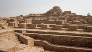
The Indus Valley or Harappan Civilisation is best known for its planned towns, drainage systems, and standardized building practices. Its urban centres show a high degree of civic organization, with clear divisions of space, uniform materials, and public utilities that set them apart from other Bronze Age cultures.
Layout and Division of Harappan Settlements
Most Harappan cities followed a dual division of urban space, though regional variations existed. The upper or fortified sector was generally placed on elevated ground, while the lower sector contained houses, workshops, and markets.
- Citadel or western sector: Usually built on an elevated mud-brick platform and protected by strong perimeter walls.
- Function of the citadel: Likely used for administrative, religious, or other civic public activities.
- Lower town or eastern sector: Larger in area and meant for the general population, including artisans, merchants, and labourers.
- Dholavira: Had a distinctive three-tier plan with a Citadel, Middle Town, and Lower Town, enclosed by a complex fortification wall.
- Chanhudaro: The only Harappan city that completely lacks a fortified citadel.
- Lothal: Had no clear wall separating the citadel from the lower town, though the administrative area was on higher ground.
Grid System and Town Planning
Harappan towns were planned geometrically rather than growing in an irregular way. Streets were laid out with a strong sense of order, reflecting careful civic control.
- Grid pattern: Streets and lanes intersected almost at right angles, creating rectangular blocks.
- Cardinal orientation: Main streets generally ran north-south and east-west.
- Wide avenues: In major cities like Mohenjo-daro, primary streets were up to 10 metres wide and could accommodate bullock carts.
- Functional zoning: Residential quarters were separated from industrial areas.
- Peripheral workshops: Bead-making, pottery, and metalworking units were often placed on the outskirts to reduce pollution in living areas.
- Specialised settlements: Chanhudaro and Lothal are notable for craft and manufacturing activity.
Architectural Features of Harappan Houses
Harappan domestic architecture shows concern for privacy, durability, and climate suitability. Houses were built with standardized bricks and arranged around internal open spaces.
- Standardized bricks: Baked bricks were common in the plains, while sun-dried bricks were used in arid zones.
- Brick ratio: The common ratio of length, width, and height was 4:2:1.
- Courtyard houses: Many homes had a central courtyard used for cooking, weaving, and daily household work.
- Side-alley entrances: Doors generally opened into side lanes rather than directly onto main streets.
- Privacy-oriented design: Street-facing walls were usually blank, with very few windows at ground level.
- Upper storeys: Staircases of brick or wood suggest that some houses had more than one floor.
- Sanitary fittings: Bathing platforms and brick latrines were connected to drains through sloping pottery pipes.
Sanitation and Drainage System
The drainage network of Harappan cities is one of the most advanced features of ancient urbanism. It reflects careful planning for hygiene, waste disposal, and maintenance.
- Brick-lined drains: Wastewater from bathrooms and latrines flowed into covered street drains.
- Covered channels: Drains were covered with burnt bricks, limestone slabs, or stone flags that could be lifted for cleaning.
- Sumps and inspection traps: These were placed at intervals to trap silt and solid waste.
- Soak pits: Wastewater often passed through settling jars or soak pits before discharge.
- Public cleanliness: The system shows a high level of civic concern for sanitation and public health.
Public Infrastructure and Specialized Components
Harappan civic authorities built large public structures for storage, ritual use, trade, and water management. These buildings reveal the scale of planning in the civilisation.
- The Great Bath, Mohenjo-daro: Located on the citadel, it measured 11.88 metres long, 7.01 metres wide, and 2.43 metres deep.
- Construction of the Great Bath: It was made of fitted burnt bricks and lined with bitumen to prevent leakage.
- Use of the Great Bath: It was likely used for public ritual bathing.
- Granaries: Large granaries were built on raised brick platforms to protect grain from flood water and dampness.
- Mohenjo-daro granary: The site had a major granary complex.
- Harappa granaries: Six circular granaries arranged in two rows are noted for air ducts that helped ventilation and drying.
- Lothal dockyard: Lothal has a massive trapezoidal basin made of fired bricks, identified as an early artificial dockyard.
- Trade link: It connected the city to the Sabarmati river basin and supported maritime trade along the Arabian Sea.
- Water control: Sluice gates were used to regulate water levels during high and low tides.
- Dholavira reservoirs: In the arid Rann of Kutch, rock-cut reservoirs and dams captured floodwaters from seasonal streams like Manhar and Mansar.
Important Site-Based Facts
| Site | Key feature |
| Mohenjo-daro | Great Bath; over 700 wells, showing heavy dependence on groundwater |
| Harappa | Granaries arranged in two rows; air ducts for ventilation |
| Dholavira | Three-tier urban plan and elaborate water harvesting system |
| Lothal | Artificial dockyard and commercial water access |
| Kalibangan | Use of mud bricks for ordinary houses; burnt bricks mainly for drains, wells, and door sills |
| Banawali | Did not follow the strict grid pattern seen at many other Harappan sites |
Key Prelims Takeaways
- Urban plan: Most Harappan cities had a citadel and a lower town, showing planned division of space.
- Exception to the rule: Dholavira had a three-tier layout, while Chanhudaro lacked a fortified citadel.
- Town planning: Streets were laid out on a grid, usually at right angles, with cardinal orientation.
- Building material: The standard burnt-brick ratio was 4:2:1.
- House design: Courtyards, side entrances, and few street-facing windows were common features.
- Drainage: Covered drains, sumps, and soak pits show advanced sanitation planning.
- Major structures: The Great Bath, granaries, Lothal dockyard, and Dholavira reservoirs are key Harappan public works.
| Related | |
|---|---|