Important Mountain and Desert Regions of North Africa
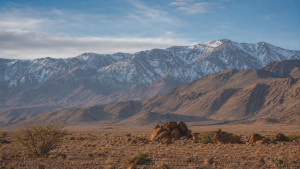
North Africa combines some of the world’s driest deserts with major mountain systems that shape climate, water availability, biodiversity, and human settlement. The Atlas chain, Saharan massifs, and desert landforms are central to the region’s geography.
The Atlas Mountain System
The Atlas Mountains form a continuous chain of fold mountains in northwestern Africa. They stretch across Morocco, Algeria, and Tunisia and separate the wet Mediterranean and Atlantic coasts from the hyper-arid Sahara Desert.
Major Sub-Ranges of the Atlas
- The High Atlas: Located in central Morocco, it contains the highest peaks in North Africa. Mount Toubkal rises to 4,167 meters, and snow remains on these peaks for most of the year.
- The Middle Atlas: Situated north of the High Atlas, it is known for limestone plateaus, cedar forests, and a colder climate.
- The Anti-Atlas: The southernmost range of the Moroccan Atlas, bordering the Sahara Desert. It consists of ancient volcanic and crystalline rocks that are heavily eroded.
- The Tell Atlas: Running parallel to the Mediterranean coast of Algeria and Tunisia, it receives the highest rainfall in the region and supports major agricultural activity.
- The Saharan Atlas: Lying south of the Tell Atlas, it forms the northern edge of the Sahara Desert. Rainfall is low and vegetation is sparse.
Geological and Ecological Value
- Orogeny: The Atlas Mountains formed during the Alpine orogeny when the African and Eurasian tectonic plates collided.
- Resources: The range contains large deposits of phosphate, iron ore, lead, zinc, and silver. Morocco has some of the world’s largest phosphate reserves.
- Biodiversity: The mountains support unique species such as the endangered Barbary macaque and Barbary leopard.
Inner Saharan Volcanic Ranges and Highlands
Far from the coastal margins, the interior of North Africa includes rugged plateaus and ancient volcanic massifs rising from the desert floor.
The Tibesti Mountains
- Location and Height: Mostly in northern Chad, extending slightly into southern Libya, this is the highest range in the Sahara Desert.
- Volcanic Peaks: Emi Koussi is the highest peak at 3,415 meters. Pic Tousside is another prominent peak known for active fumaroles.
- Climate and Water: Higher elevation brings slightly more rainfall than the surrounding desert, creating ephemeral streams and sparse vegetation.
The Ahaggar (Hoggar) Mountains
- Location and Composition: Located in southern Algeria, this highland region consists of ancient metamorphic and volcanic rocks.
- Highest Point: Mount Tahat is the highest peak in Algeria, standing at 2,908 meters.
- Human Geography: The rugged terrain is the traditional home of the Tuareg, a nomadic pastoralist group.
- Ancient Art: The cliffs of the Ahaggar and the nearby Tassili n’Ajjer plateau contain thousands of ancient rock art pieces showing a greener Sahara with cattle, giraffes, and crocodiles.
The Red Sea Hills and Sinai Mountains
- The Red Sea Hills: This fault-block mountain range runs parallel to the Red Sea in Egypt and Sudan. It is composed of igneous and metamorphic rocks and is rich in gold and copper.
- Sinai Peninsula Mountains: Located in northeastern Egypt, this rugged granite block contains Mount Catherine, the highest peak in Egypt at 2,629 meters. Mount Sinai lies nearby and has major historical and religious significance.
The Sahara Desert and Its Key Sub-Regions
The Sahara is the largest hot desert in the world, covering about 9 million square kilometers. It spans eleven countries from the Atlantic Ocean to the Red Sea.
Major Desert Sub-divisions
- The Libyan Desert (Western Desert of Egypt): Occupies western Egypt and eastern Libya. It is among the driest places on Earth and includes sand dunes, rocky plateaus, and deep depressions.
- The Nubian Desert: Located in northeastern Sudan between the Nile River and the Red Sea, it has rugged sandstone plateaus, rocky hills, and dry river valleys called wadis.
- The Eastern Desert (Arabian Desert of Egypt): Extends from the Nile River to the Red Sea and is more mountainous and rugged than the flat Western Desert.
Distinctive Landforms of the Saharan Landscape
- Ergs (Sand Seas): Vast areas of shifting sand dunes. The Great Sand Sea on the Egypt-Libya border is one of the largest ergs in the world.
- Regs (Desert Pavement): Flat plains covered with closely packed gravel and pebbles. They make up about 70 percent of the Saharan landscape.
- Hamadas: Elevated, barren rocky plateaus cleared of sand by strong desert winds.
- Oases: Isolated fertile areas watered by natural springs or underground aquifers. Examples include the Siwa Oasis in Egypt and the Kufra Oasis in Libya.
- Depressions: Low-lying basins below sea level. The Qattara Depression in Egypt is the lowest point in North Africa at 133 meters below sea level.
Comparative Overview of Key Mountain and Desert Features
| Feature Name | Type of Feature | Primary Countries | Key Elevation / Area | Unique Characteristic |
| Atlas Mountains | Fold Mountains | Morocco, Algeria, Tunisia | 4,167 m (Mount Toubkal) | Acts as a climatic barrier between the Mediterranean and the Sahara. |
| Tibesti Mountains | Volcanic Massif | Chad, Libya | 3,415 m (Emi Koussi) | Represents the highest mountain range in the Sahara Desert. |
| Ahaggar Mountains | Volcanic / Crystalline | Algeria | 2,908 m (Mount Tahat) | Features dramatic basalt columns and is the homeland of the Tuareg. |
| Libyan Desert | Hyper-arid Desert | Libya, Egypt, Sudan | ~1.1 million sq km | Contains the hyper-arid Great Sand Sea and the Qattara Depression. |
| Nubian Desert | Rocky Desert | Sudan, Eritrea | ~400,000 sq km | Sandstone landscape located between the Nile and the Red Sea Hills. |
| Sinai Mountains | Granitic Blocks | Egypt | 2,629 m (Mount Catherine) | Arid mountain block connecting the African continent to Southwest Asia. |
Hydrology and Underground Water Resources
Water is the most valuable resource in North Africa. Despite surface aridity, major water systems exist beneath the sand and rock.
The Nubian Sandstone Aquifer System (NSAS)
- Scale: The world’s largest known fossil water aquifer system, spanning over two million square kilometers across Egypt, Libya, Chad, and Sudan.
- Origin: The water was deposited tens of thousands of years ago during wet pluvial periods when North Africa received heavy rainfall.
- Utilization: Libya taps this aquifer through the Great Man-Made River project, which pumps water to coastal cities such as Tripoli and Benghazi.
Wadis and Ephemeral Drainage
- Definition: Wadis are dry river valleys that remain dry for most of the year.
- Flash Floods: During rare rainstorms, wadis channel sudden flash floods and act as natural drainage channels toward the Mediterranean Sea, the Atlantic Ocean, or closed inland basins.
Recent Context
Fog harvesting in southwest Morocco uses mesh nets to collect Atlantic fog and supply gravity-fed water to villages in the Anti-Atlas. The system, managed by Dar Si Hmad, is expanding with CloudFisher technology and local monitoring support.
Rare Facts for Prelims
- Mount Toubkal is not only the highest peak in North Africa but also a major trekking destination in Morocco.
- Emi Koussi is a shield volcano, which means it has broad, gently sloping sides rather than a steep cone.
- The Qattara Depression lies below sea level and is one of the most striking low points in Africa.
- The Great Sand Sea is a major erg where dunes can shift significantly under strong desert winds.
- Tassili n’Ajjer is famous for prehistoric rock art that records ancient environmental conditions in the Sahara.
- The Nubian Sandstone Aquifer is a fossil aquifer, meaning much of its water is ancient and not quickly replenished.
| Related | |
|---|---|