Types of Offshore Exploration Technologies
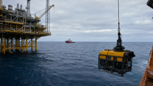
Offshore exploration uses geophysical surveys, drilling platforms, and subsea robotics to identify and verify resources beneath the ocean floor. It is increasingly important as onshore reserves decline and energy companies move into deepwater and ultra-deepwater basins.
Recent Context
India approved the Samudra Manthan National Offshore Exploration Scheme as a Central Sector Scheme under the Ministry of Petroleum & Natural Gas. The scheme focuses on seismic mapping, exploratory drilling, and shared offshore infrastructure to expand exploration capacity.
Overview of Offshore Exploration
Offshore exploration involves identifying, mapping, and evaluating resources beneath the ocean floor. These resources primarily include crude oil, natural gas, gas hydrates, and solid minerals such as polymetallic nodules.
As onshore reserves deplete, energy extraction moves into deepwater and ultra-deepwater environments. Deepwater areas range from 125 meters to 1,500 meters in depth. Ultra-deepwater areas exceed depths of 1,500 meters.
India’s Exclusive Economic Zone (EEZ) extends over 23.6 lakh square kilometres.
The restricted offshore “no-go” area was reduced from 13.67 lakh square kilometres to 24,832 square kilometres, opening 99% of India’s coastal waters for exploration.
Geophysical Mapping Technologies
Geophysical mapping is the first critical step in marine exploration. It helps geoscientists visualize subterranean rock formations without physical drilling.
Seismic Reflection Imaging
- 2D Seismic Surveys: These use a single acoustic source and a single towed cable of receivers. They generate a two-dimensional cross-sectional slice of the Earth’s crust and are mainly used for regional reconnaissance.
- 3D Seismic Surveys: These employ multiple parallel receiver cables towed behind a vessel. The dense data grid allows computers to construct three-dimensional block diagrams of subsea geology for identifying reservoir boundaries and structural traps.
- 4D Seismic Surveys: These repeat 3D seismic surveys over the same area at different time intervals. They track fluid movement, pressure changes, and temperature variations within an active reservoir.
Marine Acoustic Sources and Receivers
- Air Gun Arrays: These are pneumatic devices towed behind seismic vessels. They release highly compressed air into the water to generate controlled acoustic waves that penetrate the ocean floor.
- Hydrophones and Streamers: Hydrophones are pressure-sensitive underwater microphones placed inside long, oil-filled tubes called streamers. These streamers can stretch up to 12 kilometers behind a vessel.
- Ocean Bottom Nodes (OBN): These are self-contained, battery-powered seismic sensors placed directly on the seabed using robotic arms. They capture high-fidelity shear waves and provide clearer images than floating hydrophones.
- Ocean Bottom Cables (OBC): These are physical cables containing sensors laid flat on the seafloor. They are useful in shallow transition zones or congested marine areas where towing streamers is difficult.
Non-Seismic Geophysical Methods
- Controlled-Source Electromagnetic (CSEM) Surveys: This method transmits low-frequency electromagnetic signals from a towed source near the seabed. Receivers measure electrical resistivity to help differentiate hydrocarbons from water-saturated rocks.
- Gravity Surveys: Marine gravimeters measure minor variations in the Earth’s gravitational pull caused by density differences in subsurface rocks. They are useful for mapping salt domes.
- Magnetic Surveys: Shipborne magnetometers record variations in the Earth’s magnetic field and help map the depth and structure of crystalline basement rock beneath sedimentary basins.
Exploratory Drilling Platforms and Vessels
Once geophysical surveys identify potential reserves, exploratory drilling verifies the presence of resources. The choice of drilling unit depends on water depth, sea conditions, and mobility needs.
Shallow Water Platforms
- Barge Rigs: These are flat-bottomed floating structures towed to the site and secured using anchors. They are designed for shallow, sheltered waters and typically operate in depths of less than 5 meters.
- Jack-up Rigs: These mobile platforms have long, retractable steel legs. Once towed to the location, the legs lower until they rest firmly on the seabed, raising the drilling hull above the water surface. They operate in depths up to 120 meters.
Deepwater and Ultra-Deepwater Platforms
- Semi-submersible Rigs: These floating drilling platforms are supported by large underwater pontoons. They are anchored to the seabed or kept in position via thrusters and can operate in depths up to 3,000 meters.
- Drillships: These are ocean-going vessels equipped with a drilling derrick and a central opening called a moon pool. They are ideal for wildcat exploration in ultra-deepwater zones exceeding 3,000 meters.
Comparison of Offshore Drilling Technologies
| Technology Type | Depth Capability | Primary Positioning Method | Best Applications |
| Barge Rigs | Less than 5 meters | Anchors and spud poles | Estuaries, shallow rivers, and calm swamps |
| Jack-up Rigs | Up to 120 meters | Steel legs resting on seabed | Shallow continental shelves and coastal areas |
| Semi-submersible Rigs | Up to 3,000 meters | Mooring lines or thrusters | Deepwater environments with high wave action |
| Drillships | Over 3,000 meters | Dynamic Positioning | Ultra-deepwater, remote exploration, high mobility |
Subsea Robotics and Support Systems
Deepwater exploration relies heavily on advanced robotic systems and specialized stabilization machinery.
Remotely Operated Vehicles (ROVs) and Autonomous Underwater Vehicles (AUVs)
- Remotely Operated Vehicles (ROVs): These are tethered underwater robots controlled by operators on the surface vessel. Equipped with high-definition cameras and mechanical arms, they perform inspections, open subsea valves, guide drill strings, and collect samples.
- Autonomous Underwater Vehicles (AUVs): These are untethered, self-propelled robotic systems that follow pre-programmed paths. They use side-scan sonars, sub-bottom profilers, and magnetometers to map the seabed and locate marine hazards.
Dynamic Positioning (DP) Systems
- System Composition: A DP system consists of position-reference sensors, wind sensors, gyrocompasses, and a computer system linked to multi-directional thrusters.
- Working Principle: The system continuously calculates wind, wave, and current forces and automatically adjusts thrusters to keep the vessel exactly over the wellbore without physical anchors.
Emerging and Digital Exploration Tools
Technological advancements reduce the time and cost associated with locating offshore deposits.
Digital and Acoustic Innovations
- Distributed Acoustic Sensing (DAS): This technology uses fiber-optic cables deployed in wells or on the seabed. Laser pulses turn the cable into a continuous, high-sensitivity receiver array.
- Low-Frequency Seismic Sounding (LFS): This direct hydrocarbon indicator technology measures the natural, low-frequency resonance of the Earth’s crust over subsea structures.
- Artificial Intelligence and Machine Learning: AI algorithms process large seismic datasets and automatically identify salt domes, faults, and stratigraphic traps, reducing interpretation time from months to days.
Deep-Sea Mineral and Resource Exploration
Nations are developing technologies to explore the deep seabed for critical minerals such as copper, cobalt, nickel, and manganese.
Sampling and Coring Devices
- Piston Corers: These are weighted steel tubes with an internal piston. When dropped to the seabed, they create a partial vacuum and pull undisturbed sediment cores into the tube, preserving stratification up to 60 meters deep.
- Gravity Corers: These are simpler sampling devices that use heavy weights to plunge a steel pipe into the seabed and collect shallower core samples.
- Box Corers: These devices retrieve large, undisturbed square blocks of top sediment and are essential for analyzing benthic habitats and polymetallic nodules.
- Grab Samplers: These samplers use spring-loaded or cable-driven clamshell buckets to scoop surface sediments and minerals from the ocean floor.
Deep-Sea Manned and Unmanned Submersibles
- Manned Deep-Ocean Submersibles: These pressure-resistant vessels carry human scientists to extreme depths. India’s Matsya 6000, developed under the Samudrayaan initiative of the Deep Ocean Mission, can carry three personnel to depths of 6,000 meters.
- Deep-Sea Harvester Prototypes: Machines such as Apollo II and Eureka II test the collection of polymetallic nodules using tracked robotic crawlers with automated arms or hydraulic suction.
Rare Facts for Prelims
- UNCLOS Link: The Exclusive Economic Zone is a maritime zone recognized under the United Nations Convention on the Law of the Sea.
- India’s Import Dependence: India imports approximately 88.5% of its crude oil and about half of its natural gas requirements.
- Samudra Manthan Goal: The scheme targets reserve accretion of over 600 Million Metric Tons of Oil Equivalent (MMTOE).
- Central Sector Scheme: Such schemes are fully funded and implemented by the Union Government.
- Red Fort Tradition: The Red Fort in Delhi is the traditional venue for the Prime Minister’s Independence Day address on August 15.
- Seismic Reach: Streamers used in marine seismic surveys can extend up to 12 kilometers behind a vessel.
| Related | |
|---|---|