Major Earth Observation Technologies
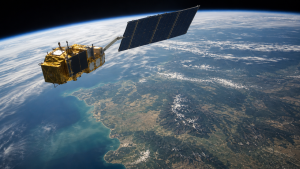
Earth observation technologies collect data on the physical, chemical and biological features of the planet. Using satellites, aircraft and drones, they help track agriculture, disasters, climate trends, land use and security-related changes with precision and repeatability.
Active and Passive Remote Sensing Systems
- Passive sensors detect naturally available energy, mainly sunlight reflected from the Earth’s surface or heat emitted by it.
- Examples include optical cameras and thermal scanners.
- Active sensors emit their own electromagnetic radiation, then measure the returned or backscattered signal from the target.
- Examples include Radar and LiDAR.
- Day-night operation is a major advantage of active sensors because they do not depend on solar illumination.
- Weather penetration is another key feature, as active sensors can often work through clouds and rain.
- Passive sensors are limited by cloud cover and daylight, so they are more effective in clear-sky daytime conditions.
Spectral Resolutions and Imaging Types
- Multispectral imaging records data in 3 to 10 broad bands such as red, green, blue and near-infrared.
- This is useful for broad classification of surface features and general land-cover mapping.
- Hyperspectral imaging captures data across hundreds of narrow, contiguous spectral bands.
- The bands are typically around 10 to 20 nanometers wide and cover visible, near-infrared and shortwave infrared regions.
- This creates a continuous spectral signature that helps identify materials more precisely than multispectral data.
- Applications include mineral mapping, crop stress detection and crop disease detection.
- Ultraspectral imaging goes further by using thousands of extremely narrow bands, though it requires heavier computation because of the data volume.
Synthetic Aperture Radar and LiDAR
- Synthetic Aperture Radar (SAR) uses the movement of the radar antenna over a target area to simulate a much larger antenna.
- This produces high-resolution two-dimensional or three-dimensional images.
- SAR works in the microwave region of the electromagnetic spectrum.
- Common SAR bands include L-band, C-band and X-band.
- These wavelengths can penetrate forest canopies and dry soil to varying degrees.
- LiDAR sends rapid laser pulses to the Earth’s surface and measures the time taken for the light to return.
- This time-of-flight method helps calculate distance with very high precision.
- Uses of LiDAR include Digital Elevation Models (DEMs) and mapping forest canopy height under dense vegetation.
Key Electromagnetic Bands in Earth Observation
| Electromagnetic Band | Wavelength Range | Primary Applications |
| Visible (RGB) | 0.4–0.7 μm | Coastal mapping, soil classification, optical photography |
| Near-Infrared (NIR) | 0.7–1.1 μm | Vegetation health monitoring, biomass estimation |
| Shortwave Infrared (SWIR) | 1.1–3.0 μm | Crop moisture tracking, mineral mapping, fire detection |
| Thermal Infrared (TIR) | 3.0–15.0 μm | Sea surface temperature tracking, volcanic thermal anomalies |
- SWIR can penetrate thin clouds and haze, which makes it useful for mineral alteration studies, crop moisture stress monitoring and locating active wildfire fronts.
- NDVI or the Normalized Difference Vegetation Index uses the contrast between red light absorption by chlorophyll and strong NIR backscatter from leaf structures to estimate vegetation density.
- Visible bands are often used for optical interpretation, while NIR and SWIR improve scientific analysis of vegetation, moisture and geology.
- Thermal infrared is important for temperature-based observations, especially where heat anomalies matter more than surface colour.
Applications in Agriculture, Disasters and Climate Monitoring
- Agriculture: Earth observation supports crop health assessment, acreage estimation, irrigation planning and early warning of moisture stress.
- Disaster management: Satellite and airborne data help detect floods, forest fires, landslides and cyclone damage, enabling faster response and damage mapping.
- Climate monitoring: EO systems are used to observe sea surface temperature, thermal anomalies, cloud patterns, vegetation change and land degradation.
- Land and water management: Remote sensing supports shoreline studies, soil classification, groundwater-related land change and biomass estimation.
- Defense and security: Radar-based systems are useful for monitoring terrain, movement and concealed surface features.
India’s Earth Observation Institutional Framework
- ISRO manages a fleet of Earth Observation satellites for national needs.
- Resourcesat is used mainly for agriculture and resource monitoring.
- Cartosat supports cartography and high-resolution mapping.
- RISAT is the radar-imaging satellite series used for all-weather observation.
- NRSC, Hyderabad, is the nodal agency for satellite data acquisition, processing and distribution in India.
- IN-SPACe regulates and authorizes private players in the commercial space sector.
- Single-window clearance for private space operations is an important role associated with IN-SPACe.
Key Prelims Takeaways
- Active vs passive sensors: Active systems emit energy and can work day and night; passive systems depend on sunlight or emitted heat.
- Hyperspectral advantage: It captures hundreds of narrow bands, allowing detailed material and chemical identification.
- Multispectral use: It records fewer, wider bands and is suitable for broader surface classification.
- SAR strength: It is valuable for all-weather imaging and can reveal terrain details even through cloud cover.
- LiDAR strength: It provides highly accurate elevation and canopy-height information using laser time-of-flight measurement.
- SWIR importance: It is useful for moisture, mineral and fire-related observations, especially in haze-prone conditions.
- Indian agencies: ISRO operates EO satellites, NRSC handles data, and IN-SPACe enables private sector participation.
Recent Context
Bengaluru-based space-tech startup Pixxel secured a USD 100 million Series C round on 7 September 2026, marking the largest single private funding round in India’s space sector. The company plans to expand its Firefly hyperspectral operations, develop the Honeybee constellation and scale manufacturing in India and the United States.
Current General Studies comprises current-affairs-based, General Studies-rich study material on policies, laws, institutions, economy, science, environment, governance, international relations, and other varied but important topics for UPSC and State PSC Prelims examinations.
Fortnightly PDF compilations: Available here
Originally written on
September 7, 2026
and last modified on
September 7, 2026.
| Related | |
|---|---|