Ram Setu
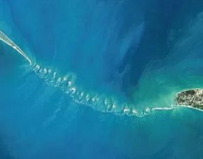
Ram Setu, also internationally known as Adam’s Bridge, is a continuous chain of limestone shoals, sandbars, and coral reefs stretching across the shallow waters of the Palk Strait. It extends roughly 48 kilometers from Dhanushkodi at the southeastern tip of Pamban Island in Tamil Nadu, India, to Talaimannar on Mannar Island off the northwestern coast of Sri Lanka. Geographically, this underwater structure acts as a natural physical barrier that separates the Palk Bay from the Gulf of Mannar. The region holds vast geological, ecological, and socio-economic importance while serving as a central feature in maritime navigation debates and historical preservation efforts.
Key Geographical and Structural Profile
The structural setup of Ram Setu forms a distinct marine landform that shapes the local oceanography. Its depth is extremely shallow, ranging from 1 to 3 meters in most stretches, making the path impassable for large ocean-going vessels.
| Geographic Metric | Details |
| Total Length | 48 kilometers (approx. 30 miles) |
| Terminal Points | Dhanushkodi (India) to Talaimannar (Sri Lanka) |
| Water Bodies Separated | Palk Bay and Gulf of Mannar |
| Composition | Sandbars, coral reefs, limestone shoals, and sandstone ledges |
| Average Water Depth | 1 to 3 meters |
| Geological Classification | Discontinuous Tombolo / Submarine Ridge |
Geological Origin and Scientific Studies
Studies conducted by the Space Applications Centre of the Indian Space Research Organisation (ISRO), using satellite imagery and laser bathymetry, have mapped the bridge as a series of 103 small patch reefs aligned atop hard sandstone and conglomerate ledges. During the Last Glacial Period, sea levels were significantly lower, providing a continuous dry land passage between India and Sri Lanka. Post-glacial sea-level rise submerged the area, while subsequent sea-level drops during the Holocene era exposed these limestone shoals. Radiocarbon dating of corals and beach sand along the chain places their formation between 4,000 and 7,000 years ago. Mainstream geological consensus views it as a tombolo—a spit or sandbar formed by longshore drift, wave action, and sediment deposition over millennia.
Ecological Significance and Biodiversity
The area surrounding Ram Setu sits inside the Gulf of Mannar Biosphere Reserve, India’s first marine biosphere reserve. The shallow waters around these reefs create a high-biodiversity ecosystem supporting rare marine organisms.
-
Coral Habitats: The patch reefs feature species of hard and soft corals that form essential spawning grounds for pelagic fish.
-
Endangered Species: The region provides a critical habitat for the endangered Dugong (Dugong dugon), commonly known as the sea cow, which feeds on extensive seagrass beds.
-
Marine Fauna: The Palk Bay ecosystem houses green sea turtles, sea cucumbers, dolphins, and numerous species of commercial fish.
-
Avian Corridors: The exposed sandbanks serve as nesting and feeding grounds for migratory wading birds moving along the Central Asian Flyway.
Sethusamudram Shipping Canal Project Debate
The Sethusamudram Shipping Canal Project was conceptualized to create a navigable sea route through the shallow waters of the Palk Strait. The project aimed to dredge a 12-meter-deep canal, enabling large commercial ships to navigate directly between the east and west coasts of India without circumnavigating Sri Lanka.
-
Economic Benefits: The proposed canal aimed to reduce maritime travel distance by up to 400 nautical miles and save roughly 21 to 36 hours of sailing time.
-
Navigational Advantage: It intended to enhance coastal shipping efficiency and strengthen maritime security in the Indian Ocean Region.
-
Environmental Concerns: Environmentalists raised alarms over severe damage to fragile coral reefs, disruption of seagrass ecosystems, and destruction of habitats for endangered marine life.
-
Geological and Economic Risks: High rates of natural siltation in the shallow ocean bed would require constant, expensive dredging, making the operational viability questionable.
-
Socio-Cultural Opposition: The proposal faced resistance due to concerns over dredging through a site held in high cultural and religious reverence.
Essential Facts
-
Ram Setu forms a natural geological barrier that buffers coastal areas in Tamil Nadu from the direct impact of storm surges and tsunamis originating in the Bay of Bengal.
-
Historical cartographic records, including 18th-century Dutch maps, refer to the region as Ramancoil before European maps adopted the name Adam’s Bridge in the 11th century.
-
The Archaeological Survey of India (ASI) has undertaken underwater surveys to study the bathymetry and sediment composition of the underwater ridge.
-
Satellite observations by ISRO confirm that only 0.02% of the structure remains above mean sea level, while the remainder forms a continuous submerged ridge.
-
The Gulf of Mannar region surrounding Ram Setu contains over 3,600 species of flora and fauna, making it one of the richest coastal regions in South Asia.
| Related | |
|---|---|