Indus Valley Civilization: Sites, Features and Chronology
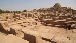
The Indus Valley Civilization, also known as the Harappan Civilization, represents the earliest known urban culture in the Indian subcontinent. Flourishing along the Indus River basin and the seasonal Ghaggar-Hakra river system, it formed one of the three major early cradle civilizations of the Old World alongside Ancient Egypt and Mesopotamia. The civilization is distinguished by its sophisticated urban planning, standardized architecture, advanced metallurgical practices, extensive trade networks, and distinct artistic traditions.
Chronology and Evolutionary Phases
Periodization Framework
Archaeologists divide the evolution of the Indus Valley Civilization into three distinct phases based on technological progress, settlement patterns, and ceramic styles. Sir Mortimer Wheeler and later Jim Shaffer established the core chronological boundaries used in contemporary historiography.
Early Harappan Phase (c. 3300 BCE – 2600 BCE)
This formative era marks the transition from rural agricultural communities to fortified regional centers. Characterized by the Hakra Phase and regional ceramic styles such as Amri, Kot Diji, and Sothi-Siswal, this period saw the initial development of trade networks, specialized crafts, and early script symbols. Key sites showing Early Harappan layers include Mehrgarh, Kalibangan, and Kot Diji.
Mature Harappan Phase (c. 2600 BCE – 1900 BCE)
This period represents the peak of urbanism, civic integration, and widespread standardization across the region. Characteristics include grid-planned cities, uniform burnt-brick dimensions, standardized weights and measures, advanced sanitation systems, and intensive long-distance trade with West Asia. Major urban centers like Harappa, Mohenjo-daro, Dholavira, Rakhigarhi, and Lothal fully developed during this era.
Late Harappan Phase (c. 1900 BCE – 1300 BCE)
This phase marks the gradual decline of urban infrastructure, de-urbanization, and the fragmentation of the integrated economic system into localized agrarian cultures. Standardized weights, seals, and long-distance trade disappeared, giving way to regional cultural variants such as the Jhukar culture in Sindh, the Cemetery H culture in Punjab, and the Lustrous Red Ware culture in Gujarat.
Major Sites and Key Discoveries
Harappa (Punjab, Pakistan)
Situated on the banks of the Ravi River, Harappa was the first site excavated in 1921 by Daya Ram Sahni under the direction of Sir John Marshall. Key finds include two rows of six granaries with working floors, clay figurines of the Mother Goddess, copper scale equipment, stone symbols of Lingam and Yoni, and evidence of the post-urban Cemetery H culture.
Mohenjo-daro (Sindh, Pakistan)
Located on the right bank of the Indus River, Mohenjo-daro was excavated in 1922 by R.D. Banerji. Known as the “Mound of the Dead,” it features the Great Bath, the Great Granary, a multi-pillared assembly hall, the famous bronze Dancing Girl statue, a steatite statuette of the Priest-King, and a terracotta seal depicting Pasupati (proto-Shiva) surrounded by animals.
Dholavira (Gujarat, India)
Discovered by J.P. Joshi in 1967 and excavated by R.S. Bisht, Dholavira is situated on Khadir Bet island in the Rann of Kutch. It features a unique three-tier city plan comprising a Citadel, Middle Town, and Lower Town. The site contains sophisticated stone-cut water reservoirs, a massive storm-water drainage network, a stadium, and a wooden signboard displaying ten large Harappan script characters.
Rakhigarhi (Haryana, India)
Located in the Hisar district of Haryana along the dried bed of the Drishadvati River, Rakhigarhi was excavated by Amarendra Nath and later Vasant Shinde. It is recognized as the largest Harappan site in the Indian subcontinent, spanning over 350 hectares. Finds include paved streets, mud-brick structures, specialized bead-making workshops, and intact human burials yielding ancient DNA samples.
Lothal (Gujarat, India)
Excavated by S.R. Rao in 1954, Lothal sits near the Gulf of Khambhat on the Bhogavo River. The site features a rectangular burnt-brick structure identified as the world’s earliest known tidal dockyard. Other major discoveries include Persian Gulf seals, terracotta models of ships, ivory measuring scales, double burials, and evidence of rice husk impressions.
Kalibangan (Rajasthan, India)
Situated on the banks of the Ghaggar River in the Hanumangarh district, Kalibangan was excavated by A. Ghosh in 1953 and later by B.B. Lal and B.K. Thapar. The site provides the earliest evidence of a ploughed agricultural field showing cross-grid furrows. It contains fire altars, camel bones, wooden drainage channels, and both mud-brick fortification walls and civilian housing.
Banawali (Haryana, India)
Located in the Fatehabad district of Haryana, Banawali was excavated by R.S. Bisht in 1974. The site contains evidence of both Early and Mature Harappan phases. Key artifacts include a high-quality clay model of a plough, large quantities of barley grains, and radial city layouts lacking the traditional grid arrangement seen in other Harappan cities.
Chanhudaro (Sindh, Pakistan)
Excavated by N.G. Majumdar in 1931 and Ernest Mackay in 1935, Chanhudaro lies south of Mohenjo-daro. It is the only Harappan city lacking a fortified citadel. The site functioned as an industrial hub specializing in bead-making, shell-cutting, and seal-engraving. Discoveries include terracotta models of bullock carts, inkpots, and a brick bearing the footprint of a dog chasing a cat.
Surkotada (Gujarat, India)
Discovered by J.P. Joshi in 1964 in the Kutch district of Gujarat, Surkotada contains a fortified citadel and residential complex made of stone rubble and mud-brick. The site is notable for yielding actual skeletal remains of horses dating to around 2000 BCE, along with oval graves and stone-covered pit burials.
Core Salient Features
Town Planning and Civic Infrastructure
Harappan cities followed a grid system where main roads cut each other at right angles, dividing the urban area into rectangular blocks. Cities typically featured two distinct parts: an elevated Citadel on the west housing public buildings, administrative centers, and granaries, and a larger Lower Town on the east containing residential quarters. Buildings were constructed using standardized burnt bricks with a uniform ratio of 1:2:4 in thickness, width, and length.
Drainage and Sanitation Architecture
Street drains ran alongside roads and were covered with loose brick or limestone slabs for regular maintenance and inspection. House drains discharged wastewater into main street drains through underground terracotta pipes and soak pits. Drains featured sumps and silt-traps to collect solid waste, reflecting advanced civic hygiene practices.
Agriculture and Food Economy
Agriculture formed the primary base of the Harappan economy. Crops included wheat, barley, sesame, mustard, chickpea, field pea, and dates. Lothal and Rangpur yielded evidence of rice cultivation. Harappans were the earliest known producers of cotton, referred to as Sindon by the Greeks. Irrigation relied on seasonal river inundation, bunds, and stone reservoirs, with channel irrigation evidence found at Shortugai in Afghanistan.
Economic System, Trade, and Crafts
The economy relied on internal barter and long-distance maritime and overland trade networks. Harappan seals, weights, and beads have been discovered in Mesopotamian cities like Ur, Kish, and Nippur. Mesopotamian texts refer to the Indus region as Meluhha, trading partners such as Dilmun (Bahrain), and Magan (Oman coast). Exports included lapis lazuli, carnelian beads, ivory products, timber, and cotton textiles, while imports included copper from the Khetri mines of Rajasthan and Oman, tin from Afghanistan, and gold from South India.
Religious Practices and Social Structure
Evidence points to a secular administrative structure, as no temples, royal palaces, or definitive monuments to military rulers have been found. Religious life involved worshipping nature, the Mother Goddess (represented in abundant terracotta figurines), and a male deity identified as Pasupati (Proto-Shiva) seated in a yogic posture surrounded by an elephant, tiger, rhino, buffalo, and two deer. Tree worship (specifically the Pipal tree), animal worship (such as the unicorn and humpback bull), and water purification rituals were widely practiced.
Script, Seals, and Weights
The Harappan script remains undeciphered. It is pictographic, containing between 400 and 600 distinct symbols, and uses a boustrophedon writing style (alternating directions from right-to-left and left-to-right). Seals were primarily carved from steatite in square or rectangular shapes, featuring animal motifs alongside brief inscriptions. Weights were standardized in a binary system for lower denominations (1, 2, 4, 8, 16, 32, 64) and a decimal system for higher values, using chert and agate stones.
Comparative Overview of Major Harappan Sites
| Site Name | Geographic Location | Associated River | Key Archaeological Discoveries |
| Harappa | Punjab, Pakistan | Ravi | Great Granary, copper scale, Mother Goddess figurines, Cemetery H |
| Mohenjo-daro | Sindh, Pakistan | Indus | Great Bath, bronze Dancing Girl, Priest-King statue, Pasupati seal |
| Dholavira | Gujarat, India | Luni (Khadir Bet) | Three-tier town planning, stone-cut reservoirs, 10-symbol signboard |
| Lothal | Gujarat, India | Bhogavo | Tidal dockyard, double burials, terracotta ship models, Persian seal |
| Kalibangan | Rajasthan, India | Ghaggar | Ploughed field surface, fire altars, camel bones, wooden drains |
| Banawali | Haryana, India | Saraswati (dried) | Clay model of a plough, high quality barley, non-grid radial layout |
| Chanhudaro | Sindh, Pakistan | Indus | Industrial bead factory, absence of citadel, footprint of dog chasing cat |
| Surkotada | Gujarat, India | Bhadar | Horse bone remains, stone-rubble fortification, stone-covered pit graves |
Facts for Quick Revision
- Sir John Marshall was the Director-General of the Archaeological Survey of India who officially announced the discovery of the Indus Valley Civilization in 1924.
- The northernmost boundary of the civilization was Manda (Jammu and Kashmir), the southernmost was Daimabad (Maharashtra), the easternmost was Alamgirpur (Uttar Pradesh), and the westernmost was Sutkagan Dor (Pakistan-Iran border).
- Mehrgarh in Balochistan, Pakistan, provides the earliest evidence of agriculture and settled pastoral life in the Indian subcontinent, dating to c. 7000 BCE.
- The lost-wax casting technique (cire perdue) was used to create metal sculptures like the famous bronze Dancing Girl of Mohenjo-daro.
- Steatite (soapstone) served as the primary raw material for manufacturing Harappan seals and decorative beads.
- Shortugai in northern Afghanistan functioned as a specialized Harappan trading colony established to exploit local lapis lazuli sources.
- Rakhigarhi in Haryana and Dholavira in Gujarat are designated as national heritage sites under central protection.
- Dholavira was inscribed as a UNESCO World Heritage Site in July 2021.
- The term Sindon, used by ancient Mesopotamians and Greeks for cotton, directly references the Indus (Sindhu) region.
- Burial practices included complete earth burials, fractional burials, and post-cremation urn burials, with bodies aligned in a north-to-south orientation.