Important Boundary Disputes of India
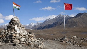
India’s boundary disputes are shaped by colonial-era maps, treaty interpretations, strategic terrain and shifting river courses. They remain central to border management, territorial integrity and diplomatic negotiations. For Prelims, the key is to remember the disputed sectors, the legal or historical basis of each claim, and the de facto arrangements that govern day-to-day control.
India-China Boundary Dispute
The India-China boundary dispute is the most complex of India’s land boundary issues and stretches across three broad sectors: western, middle and eastern. The dispute largely arises from differing interpretations of historical treaties, legacy maps and the absence of a mutually demarcated border.
- Western sector (Ladakh): The main disputed area is Aksai Chin, a high-altitude plateau claimed by India as part of the Union Territory of Ladakh but administered by China.
- India’s position: It is based on the Johnson Line (1865) and the Johnson-Ardagh Line (1897), both of which place Aksai Chin within the erstwhile princely state of Jammu and Kashmir.
- China’s position: China cites historical control and the Macartney-MacDonald Line (1899) to support its claim.
- Middle sector: Covering Himachal Pradesh and Uttarakhand, this is the least disputed sector and extends for about 200 km. The border here is largely aligned with the watershed principle.
- Barahoti: A small area in Uttarakhand that remains contentious.
- Eastern sector: This includes the boundary between Arunachal Pradesh and the Tibet Autonomous Region. China claims almost all of Arunachal Pradesh, calling it “South Tibet”.
- McMahon Line: Drawn in 1914 at the Simla Convention, it is accepted by India as the international border and functions as the de facto boundary in this sector.
- Tawang: A strategically important town in Arunachal Pradesh and a key point of contention.
- Line of Actual Control (LAC): The LAC is the de facto boundary between India and China. It is not fully demarcated on maps or on the ground, which leads to differing perceptions and periodic stand-offs.
- Bilateral agreements: Agreements in 1993, 1996, 2005 and 2013 sought to maintain peace and tranquillity along the LAC.
India-Pakistan Boundary Dispute
The India-Pakistan boundary is highly militarised and has been shaped by Partition, wars and unresolved questions in Jammu and Kashmir. The principal de facto line is the Line of Control, while Siachen and Sir Creek remain major dispute points.
- Jammu and Kashmir: The core dispute area, partitioned by the Line of Control (LoC).
- Line of Control (LoC): It emerged from the 1948 ceasefire line and was formally established after the 1971 war under the Simla Agreement (1972). It is not an internationally recognised boundary.
- Siachen Glacier: Located in the eastern Karakoram range, it is the world’s highest battleground.
- Basis of Siachen dispute: Both India and Pakistan claim sovereignty over the glacier. The dispute arose from ambiguous demarcation beyond NJ9842 in the Karachi Agreement of 1949.
- Sir Creek: A 96-km tidal estuary in the Rann of Kutch marshland between Gujarat and Sindh.
- India’s claim: India holds the eastern bank as the boundary, based on a 1914 Bombay Government Resolution.
- Pakistan’s claim: Pakistan supports the center of the creek using the Thalweg Doctrine.
- Strategic importance: Sir Creek is relevant for possible oil and gas reserves and fishing rights.
India-Nepal Boundary Dispute
India and Nepal share an open border of over 1,850 km. The boundary is generally peaceful, but a few stretches remain contested because of differing treaty interpretations and changing river courses.
- Kalapani-Lipulekh-Limpiyadhura: This triangular Himalayan region is the main dispute area.
- India’s administration: India administers Kalapani as part of Uttarakhand’s Pithoragarh district.
- Nepal’s claim: Nepal claims the area as part of its Darchula district.
- Treaty basis: The dispute stems from differing readings of the Treaty of Sugauli (1816), especially on the origin of the Kali River, which defines part of the boundary.
- Lipulekh Pass: It is strategically important as a trade route and as a pilgrimage route to Kailash Mansarovar.
- Susta: A disputed territory in the Terai region on the border of Bihar and Rupandehi District.
- Cause of dispute: The shifting course of the Gandak River (Narayani River in Nepal) has altered the local boundary alignment.
India-Bangladesh Boundary Dispute
India and Bangladesh share a 4,096-km land boundary. This border issue was among the most technically complex in South Asia, but the Land Boundary Agreement resolved most long-pending problems, especially enclaves and undemarcated stretches.
- Land Boundary Agreement (LBA), 2015: A landmark settlement formalised through the 100th Constitutional Amendment Act.
- Enclaves: The agreement resolved the long-standing issue of chitmahals.
- Exchange of enclaves: India transferred 111 enclaves to Bangladesh and received 51 Bangladeshi enclaves in return.
- Other issues: The LBA also resolved adverse possessions and undemarcated stretches of the border.
- Tin Bigha Corridor: A strip of Indian territory leased to Bangladesh in 1992 to provide access to Dahagram–Angarpota enclaves.
- Maritime boundary: A Permanent Court of Arbitration ruling in 2014 largely settled the sea boundary dispute in the Bay of Bengal.
- Outcome of ruling: Bangladesh was awarded an area of 19,467 sq km.
Key Prelims Takeaways
- India-China: The three sectors are western, middle and eastern; the main disputed areas are Aksai Chin and Arunachal Pradesh.
- Western sector: India cites the Johnson Line and Johnson-Ardagh Line; China refers to the Macartney-MacDonald Line.
- Eastern sector: India accepts the McMahon Line; China rejects it and calls Arunachal Pradesh “South Tibet”.
- LAC: The Line of Actual Control is the de facto boundary between India and China and is not fully demarcated.
- India-Pakistan: The LoC is the de facto line in Jammu and Kashmir and emerged from the ceasefire line of 1948.
- Siachen: The dispute is linked to the undefined boundary beyond NJ9842 in the Karachi Agreement (1949).
- Sir Creek: Pakistan favours the Thalweg Doctrine, while India cites the 1914 Bombay Government Resolution.
- India-Nepal: Kalapani-Lipulekh-Limpiyadhura is linked to the Treaty of Sugauli (1816) and the origin of the Kali River.
- Susta: The dispute is linked to the changing course of the Gandak River.
- India-Bangladesh: The 2015 Land Boundary Agreement resolved enclaves, adverse possessions and many undemarcated stretches.
Recent Context
India objected to a United Nations world map issued on July 1, 2026, under the Equal Earth projection, which showed anomalies in Arunachal Pradesh and Aksai Chin. The MEA reiterated that Arunachal Pradesh is an integral part of India and Aksai Chin is part of Ladakh, and that India’s sovereign territory must be shown as per its official map.
| Related | |
|---|---|