Great Trigonometrical Survey Began at St. Thomas Mount
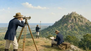
The Great Trigonometrical Survey began in 1802 to measure India’s land area, distances and elevations. British surveyor William Lambton led the work, using trigonometry to extend measurements across the country.
Lambton selected St. Thomas Mount in Chennai for India’s first baseline measurement. The line, about 12.2 kilometres long, ran between St. Thomas Mount and Perumbakkam Hill, near Guindy Racecourse. More than 100 measuring chains were used.
Surveyors used instruments including the theodolite. They measured across varied terrain and used the results to extend the survey through connected triangles. The survey’s data supported mapping and later calculations, including work to determine the height of Mount Everest.
Notable Points
- The first baseline and the survey’s name: The Great Trigonometrical Survey began on 10 April 1802 with a 7.5-mile (12.1-km) baseline from St. Thomas Mount to Perumbauk Hill near Madras. The measurement was completed on 22 May. The survey received its official name only in 1818.
- Pundit surveyors: Himalayan surveyors who worked in Tibet, where Europeans were not allowed, were called pundits. They included cousins Nain Singh Rawat and Kishen Singh Rawat.
Category: Tamil Nadu
Originally written on
November 21, 2026
and last modified on
November 21, 2026.
| Related | |
|---|---|