NISAR
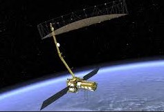
The NASA-ISRO Synthetic Aperture Radar (NISAR) project is a joint Earth-observation satellite mission developed by the National Aeronautics and Space Administration (NASA) and the Indian Space Research Organisation (ISRO). It is designed to map the entire Earth every 12 days using advanced radar imaging. Operating in a Sun-Synchronous Orbit (SSO) at an altitude of approximately 747 kilometers, NISAR provides high-resolution, all-weather, day-and-night measurements of changes in Earth’s crust, ecosystems, ice masses, and natural hazards.
Technical Architecture and Agency Division
NISAR is the first space mission to systematically use two different radar frequencies—L-band and S-band—to observe land and ice dynamics. The payload features a 12-meter unfurlable mesh reflector antenna mounted on a 9-meter deployable boom, utilizing the “SweepSAR” technique to collect high-resolution radar data across a wide 242-kilometer swath.
Partner Contributions
The responsibility for developing the observatory was split between NASA and ISRO through a bilateral agreement.
| System / Component | Contributing Agency | Primary Specifications & Functions |
| L-band SAR | NASA (Jet Propulsion Laboratory) | Wavelength ~24 cm; deeper penetration for dense forest canopy, soil moisture, and crustal deformation. |
| S-band SAR | ISRO (Space Applications Centre) | Wavelength ~9.4 cm; sensitive to light vegetation, crop monitoring, and coastal dynamics. |
| Deployable Antenna System | NASA / JPL | 12-meter gold-plated mesh reflector and 9-meter boom shared by both SAR payloads. |
| Satellite Bus & Platform | ISRO | Provides power, thermal management, attitude control, and propulsion systems. |
| Telemetry & Data Recorders | NASA / ISRO | High-rate telecom, GPS receivers, and solid-state storage systems. |
| Launch Vehicle | ISRO | Geosynchronous Satellite Launch Vehicle (GSLV Mark II). |
Key Application Areas
NISAR tracks dynamic surface processes across terrestrial and aquatic ecosystems, offering crucial inputs for scientific research and governance.
Ecosystem and Biomass Dynamics
The dual-frequency radar measures forest canopy height, carbon stocks, and disturbances in dense ecosystems such as the Western Ghats and Amazon basin. It supports global carbon cycle modeling by quantifying biomass loss from deforestation and land-use change.
Disaster Management and Hazards
NISAR detects surface deformation with sub-centimeter accuracy before and after natural events. It provides critical mapping data for volcanic eruptions, earthquake fault line displacements, landslides in mountainous zones like the Himalayas, and flood extent during extreme weather events.
Cryosphere Monitoring
The mission tracks velocity profiles of polar ice sheets in Antarctica and Greenland, sea ice movement, and retreat patterns of Himalayan alpine glaciers. These inputs aid in assessing global sea-level rise and regional water security risks.
Hydrology and Coastal Processes
NISAR provides global surface soil moisture estimates at a 200-to-400-meter spatial resolution. It measures seasonal groundwater depletion, wetlands like the Vembanad-Kol, coastal shoreline accretion, and marine oil spill footprints.
Key Facts for Quick Revision
-
Mission Type: Earth Observation Satellite (EOS) / Synthetic Aperture Radar Imaging.
-
Executing Agencies: ISRO (India) and NASA (USA).
-
Orbital Parameters: Sun-Synchronous Orbit (SSO) at ~747 km altitude; 98.4° inclination.
-
Repeat Cycle: 12-day global coverage; 6-day repeat cycle combining ascending/descending passes.
-
Primary Frequencies: L-band (24 cm wavelength) and S-band (9.4 cm wavelength).
-
Core Technique: Interferometric Synthetic Aperture Radar (InSAR) paired with SweepSAR technology.
-
Spatial Resolution: 3 to 10 meters depending on the operational acquisition mode.
-
Data Accessibility: Open-access data policy hosted via Alaska Satellite Facility (L-band) and ISRO’s Bhoonidhi portal (S-band and global L-band access).