New Islands Emerge After Anak Krakatau Eruption
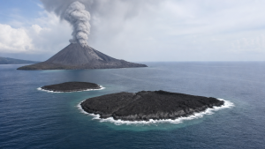
Two new islands have emerged off Indonesia’s Anak Krakatau volcano after a 25-hour continuous eruption between 4 and 6 September 2026. The formations were first noted by mariners and volunteers around 22 September 2026 and were verified through Sentinel satellite imagery on 23 September 2026.
Anak Krakatau and Krakatoa
Anak Krakatau means “Child of Krakatoa” and is a volcanic island in the Sunda Strait between Java and Sumatra. It formed after the 1883 Krakatoa eruption, one of the most destructive volcanic events in recorded history.
The 2026 eruption expanded Anak Krakatau’s land area by nearly 32.8 hectares, or about 0.2 square kilometres, through lava flows and pyroclastic material. Pyroclastic material includes ash, lapilli, volcanic bombs, and fragmented rock ejected during explosive eruptions.
Location and Geological Features
Indonesia’s Geological Agency placed one new island about 760 metres north-west of Anak Krakatau and the other about 495 metres south-east of it. Both formations lie along a north-west to south-east axis through the volcano’s crater.
The exact nature of the islands remains unconfirmed, and preliminary interpretations classify them as possible new eruption vents or accumulations of secondary eruptive material. Secondary eruptive material includes deposits formed after the main eruption by reworking of volcanic debris.
Volcanic Monitoring and Hazard Zones
Indonesia’s Geological Agency raised Anak Krakatau’s alert level to Level III on 2 July 2026 and later downgraded it to Level II on 21 September 2026 after volcanic activity declined. The agency has set a 2-kilometre exclusion zone around the main crater and a 1-kilometre exclusion zone around the two new islands as of 24 September 2026.
The eruption caused temporary closure of Jakarta’s international airport and several regional airports, affecting thousands of flights and passengers. Volcanic alert levels in Indonesia are part of a four-tier system used for active volcano monitoring.
Important Facts for Exams
- Anak Krakatau is located in the Sunda Strait, which separates Java and Sumatra.
- The 1883 Krakatoa eruption generated tsunamis and is a major reference point in global volcanology.
- Sentinel satellites are part of the European Union’s Copernicus Earth observation programme.
- Volcanic islands can disappear or change shape because of erosion, tides, and repeated eruptions.
Island Formation and Volcanic Landforms
Volcanic islands can form when lava and ash accumulate above sea level over time. The long-term survival of such islands depends on resistance to marine erosion, wave action, and tidal forces.
| Related | |
|---|---|