Guatemala
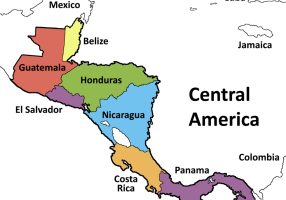
Guatemala is a Central American country bordered by Mexico to the north and west, Belize and the Caribbean Sea to the northeast, Honduras to the east, El Salvador to the southeast, and the Pacific Ocean to the south. Its capital and largest city is Guatemala City. It was the historical core of the ancient Maya civilization before Spanish colonization.
Geographic Profile and Physical Features
Guatemala occupies a strategic position on the Central American isthmus, bridging North and South America.
Physical Geography
- The country has three main geographic zones: the central highlands, the Pacific coastal plains, and the northern lowlands known as Petén.
- The Sierra Madre de Chiapas mountain range runs across the south, parallel to the Pacific coast.
- The Sierra de los Cuchumatanes forms the highest non-volcanic mountain range in Central America.
- Volcán Tajumulco is the highest peak in Central America, reaching an elevation of 4,220 meters.
- The country hosts over 30 volcanoes, including active ones such as Volcán de Fuego, Pacaya, and Santiaguito.
Hydrology and Climate
- Lake Atitlán is a deep endorheic caldera lake surrounded by three volcanoes: Atitlán, San Pedro, and Tolimán.
- Lake Izabal is the largest lake in Guatemala, draining into the Caribbean Sea via the Dulce River.
- The Motagua River is the longest river entirely within Guatemala and marks a major tectonic fault line.
- The Usumacinta River forms part of the international border with Mexico.
- The climate ranges from hot and humid tropical lowlands to temperate mountain valleys and cold alpine highlands.
Overview Profile
| Parameter | Details |
| Capital | Guatemala City |
| Official Language | Spanish (along with 22 recognized Mayan languages, Garifuna, and Xinca) |
| Government Type | Unitary presidential constitutional republic |
| Legislature | Congress of the Republic (Unicameral) |
| Currency | Guatemalan Quetzal (GTQ) |
| Highest Point | Volcán Tajumulco (4,220 m) |
| Major Lakes | Lake Izabal, Lake Atitlán, Lake Petén Itzá |
| Major Rivers | Motagua River, Usumacinta River, Dulce River |
History and Civilization
Human settlement in Guatemala dates back millennia, marked by advanced pre-Columbian societies and later colonial rule.
Pre-Columbian to Colonial Era
- Guatemala was the cultural heartland of the Classic Period Maya civilization from 250 CE to 900 CE.
- Tikal, located in the northern department of Petén, served as a dominant Maya political and ceremonial power center.
- Pedro de Alvarado led the Spanish conquest of the region in 1524.
- The Captaincy General of Guatemala served as the administrative center for Central America under the Viceroyalty of New Spain.
- Antigua Guatemala served as the colonial capital until major earthquakes destroyed it in 1773, prompting the move to present-day Guatemala City.
Modern History
- Guatemala gained independence from Spain on September 15, 1821.
- It briefly formed part of the First Mexican Empire and then the Federal Republic of Central America before declaring full sovereignty in 1847.
- A 36-year civil war took place between 1960 and 1996, ending with the signing of the Accord for a Firm and Lasting Peace.
Economy and Resources
Guatemala has the largest economy in Central America by gross domestic product.
- Agriculture remains an essential pillar of employment and export revenues.
- Major agricultural export commodities include coffee, bananas, raw sugar, palm oil, and cardamom.
- Guatemala is one of the world’s leading producers and exporters of green cardamom.
- The manufacturing sector focuses on textiles, apparel assembly, food processing, and light chemicals.
- Remittances sent from citizens working abroad contribute a large portion of annual foreign exchange inflows.
- Natural resources include petroleum in the Petén basin, nickel, timber, and hydroelectric potential.
Biodiversity and Conservation
Guatemala lies within the Mesoamerican Biodiversity Hotspot, featuring high levels of endemism.
- The Maya Biosphere Reserve in Petén covers over two million hectares, protecting dense tropical moist forests and archaeological ruins.
- The national bird is the Resplendent Quetzal, known for its iridescent green plumage and cultural connection to pre-Columbian folklore.
- The cloud forests of Baja Verapaz and Alta Verapaz provide primary habitats for epiphytes, orchids, and endemic amphibians.
- The Monja Blanca (White Nun Orchid) is the national flower of Guatemala.
Important Facts
- Guatemala is the most populous country in Central America.
- The country’s currency, the Quetzal, is named after the national bird.
- Tikal National Park was inscribed as one of the first mixed UNESCO World Heritage Sites in 1979 for both cultural and natural criteria.
- Antigua Guatemala is a preserved colonial city designated as a UNESCO World Heritage Site.
- The archaeological park and ruins of Quiriguá contain the tallest sculpted stone monuments (stelae) in the New World.
- The Motagua Fault and the Chixoy-Polochic Fault form the boundary zone between the North American Plate and the Caribbean Plate, causing frequent seismic activity.
- Guatemala borders four countries: Mexico, Belize, Honduras, and El Salvador.
- The national tree of Guatemala is the Ceiba (Ceiba pentandra), sacred in ancient Mayan cosmology.