Fire Clouds and Europe’s Wildfires
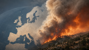
A pyrocumulonimbus cloud, also called a fire cloud or pyroCb, formed over a wildfire near Saumos in the Gironde region of southwest France on 24 July 2026. The blaze began on 22 July 2026 and had burned more than 420 square kilometres of forests and scrubland by 27 July 2026.
What is a Pyrocumulonimbus Cloud?
A pyrocumulonimbus cloud is a fire-generated thunderstorm cloud formed when intense heat from a wildfire lifts smoke, ash, and moisture high into the atmosphere. The rising column of hot air can develop into a thunderstorm cloud that produces lightning, strong winds, and turbulent weather around the fire zone.
Formation and Behaviour
Pyrocumulonimbus clouds form when a wildfire releases enough heat to create a powerful updraft. The updraft can carry water vapour and combustion particles to high altitudes, where condensation and storm development occur. Such clouds can generate lightning that starts new fires and can produce violent, erratic winds that alter fire direction and speed.
Wildfires in France and Spain
The wildfire near Saumos damaged or destroyed more than 240 homes and forced 220,000 people to evacuate in Gironde by 27 July 2026. Across France and Spain, about 325,000 to 360,000 people were evacuated in July 2026 as several fires created their own weather systems, including pyrocumulonimbus clouds.
Important Facts for Exams
- Pyrocumulonimbus clouds are also known as fire clouds or pyroCb clouds.
- Australia and North America have recorded pyrocumulonimbus clouds more commonly than France.
- The National Firefighters Federation of France had not officially recorded a pyroCb cloud in the country before July 2026.
- “Weather whiplash” refers to a sharp swing from wet conditions to dry conditions.
Climate and Fire Risk
Hotter and drier conditions increase the likelihood of extreme wildfires and pyrocumulonimbus formation. Human-caused climate change is linked to the growing frequency and intensity of such fire behaviour in Europe.
| Related | |
|---|---|