Bihar Remote Sensing Centre Signs MoU with Survey of India for Geospatial Applications
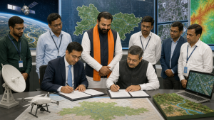
The Bihar Remote Sensing Application Centre (BIRSAC) and the Survey of India (SOI) signed a Memorandum of Understanding (MoU) in Patna on 29 October 2026. The agreement was signed during the Space Application Adoption Workshop 2026, attended by Bihar Chief Minister Samrat Choudhary.
Geospatial cooperation in Bihar
The MoU provides for technical collaboration in geospatial data sharing, capacity building and joint projects. Its stated aim is to support development and disaster-management applications in Bihar. Choudhary emphasised integrating space-based technologies, scientific solutions and innovation into the state’s development and administrative systems.
The Chief Minister also launched the TechConnect portal at the event.
Important Facts for Exams
- Geospatial divisions: Survey of India’s 18 geospatial divisions cover functions ranging from tide prediction to aerial surveying.
- Geographical names: Survey of India is responsible for the naming conventions and spellings of India’s geographical features.
- National geodetic control: Survey of India maintains India’s national geodetic control framework, enabling mapping agencies to position surveys against a common spatial reference.
- Geospatial data policy: India’s 2022 National Geospatial Policy generally removed prior-approval requirements for Indian entities collecting and processing geospatial data, while retaining restrictions for sensitive information.
Originally written on
October 31, 2026
and last modified on
October 31, 2026.
| Related | |
|---|---|