X-band Doppler Weather Radar Commissioned at Mahabaleshwar
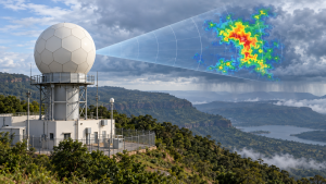
An X-band Dual-Polarization Doppler Weather Radar was inaugurated on 24 April 2026 at the High Altitude Cloud Physics Laboratory in Mahabaleshwar, Maharashtra. Dr M. Ravichandran, Secretary of the Ministry of Earth Sciences, inaugurated the system, commissioned by the Indian Institute of Tropical Meteorology (IITM) under Mission Mausam.
Radar capabilities and coverage
Located at about 1,400 metres above mean sea level in the Western Ghats, the radar scans the atmosphere in real time to track rainfall, clouds and storms. It provides high-resolution data on precipitation characteristics, drop size distribution and storm structure. Its monitoring and nowcasting support extends up to three hours for Satara, Pune, parts of Konkan and Mumbai. The system is also intended to support studies of orographic rainfall, monsoon dynamics and deep convective processes, as well as applications including flood and landslide warnings, aviation safety, agriculture advisories, disaster management and water-resource planning.
IITM–ISRO collaboration
IITM signed a memorandum of understanding with the Indian Space Research Organisation’s Space Applications Centre to co-develop satellite-based meteorological products. The commissioning event was attended by IITM Director A. Suryachandra Rao and Space Applications Centre Director Somya S. Sarkar.
Important Facts for Exams
- X-band range: X-band weather radar uses a 3-centimetre wavelength and is used for short-range units.
- Doppler returns: Doppler radar detects rain-droplet motion as well as precipitation intensity; analysing both helps reveal storm structure and severe-weather potential.
- Reflectivity sensitivity: Radar reflectivity varies with the sixth power of raindrop diameter, making drop-size distribution important when interpreting precipitation returns.
| Related | |
|---|---|