Jaipur Range Police Introduces QR Codes for Road Black Spots
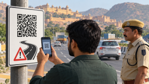
In April 2026, the Jaipur Range Police introduced a QR-code system under its Mission Safer Road campaign to give motorists information about accident-prone road locations, known as black spots.
Survey Identifies 121 Black Spots
A police survey identified 121 black spots across eight districts in the Jaipur Range. Crashes at these locations caused 1,108 deaths over three years. The police classified locations with more than 20 fatalities as Red Zone, those with 10–20 as Orange Zone, and those with fewer than 10 as Yellow Zone. The survey found six Red Zone, 37 Orange Zone and 78 Yellow Zone spots.
QR Codes and Planned Google Maps Integration
The QR codes were displayed at toll plazas, police stations, transport hubs and other public places for commuters to scan. The police coordinated with Google, which supported plans to integrate the black spots into Google Maps and provide related alerts. Direct integration into Google Maps was planned for the coming days or months; it had not yet been implemented.
Important Facts for Exams
- Image detection: Unlike one-dimensional barcodes read by a narrow light beam, QR codes are detected as digital images and analysed by a processor.
- Indian black-spot criterion: For Indian National Highways, the conventional black-spot criterion is a 500-metre stretch with five qualifying crashes or ten fatalities over three years.
- QR error correction: QR Code Model 2 uses Reed–Solomon error correction, with four correction levels that allow data recovery even when part of the code is damaged.
- National road-safety governance: Section 215B of the Motor Vehicles Act, inserted in 2019, empowers the Union government to constitute a National Road Safety Board advising on road standards and traffic management.
| Related | |
|---|---|