Andhra Pradesh Floods Damage Crops and Cut Village Access
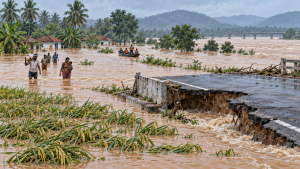
Heavy rain and flooding affected several districts of Andhra Pradesh in late September 2026, damaging crops, roads and bridges and disrupting access to villages. In North Andhra, the Nagavali and Vamsadhara rivers were in spate after incessant rain and upstream floodwaters.
Crop and Infrastructure Damage
About 12,022 hectares of paddy were submerged across nine mandals in Srikakulam district. Cashew, banana, papaya and coconut crops were also damaged. Around 239 kilometres of roads were damaged in Srikakulam, while Kakinada district recorded damage to 133 kilometres of Roads and Buildings roads. Flooding affected agency villages in Alluri Sitarama Raju and Polavaram districts, where bridges and culverts were washed away and hill streams overflowed. Lanka villages in the Godavari region, particularly in Polavaram and Dr. B.R. Ambedkar Konaseema districts, also faced flooding and disrupted transport.
Warnings and Evacuations
Severe impacts were reported in Srikakulam, Vizianagaram, Parvathipuram Manyam, Visakhapatnam, Anakapalle, Alluri Sitarama Raju, Kakinada, Eluru, West Godavari, East Godavari, Polavaram and Dr. B.R. Ambedkar Konaseema. Authorities issued flood warnings and released water from Madduvalasa, Thotapalli, Gotta Barrage, Bhupathipalem, Gambhiram, Duduma and Dhavaleswaram. More than 170 people were moved from flood-prone villages to safer centres in Srikakulam; evacuation efforts were also under way in Kakinada, Polavaram and Dr. B.R. Ambedkar Konaseema.
Important Facts for Exams
- Basin position: Nagavali is an interstate river of southern Odisha and Andhra Pradesh, positioned between the Rushikulya and Godavari basins.
- Water-sharing arrangement: A tribunal upheld equal sharing of the Vamsadhara’s 115 TMC yield at Gotta Barrage between Andhra Pradesh and Odisha.
- Construction-stage flood passage: The original Dhawaleswaram Barrage was built in four sections, allowing flood passage during construction.
| Related | |
|---|---|