Important Features of the Tibetan Plateau and Its Climate
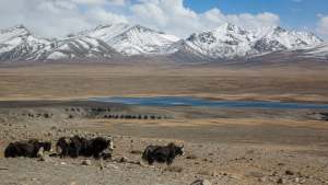
The Tibetan Plateau is a high-elevation region of Central Asia whose glaciers, permafrost, rivers and alpine ecosystems shape its environmental significance. Its elevation and seasonal heating influence atmospheric circulation and the Asian monsoon, while changes in ice, snow and precipitation can affect water availability across the plateau and downstream.
Geographical Setting and Geological Formation
- Extent and elevation: The plateau covers more than 2.5 million square kilometres and has an average elevation above 4,500 metres. It is also called the “Roof of the World” and the “Third Pole”.
- Boundaries and terrain: The Himalayas lie to the south, the Kunlun Mountains to the north and the Karakoram Range to the west. Its landscape includes alpine grasslands, rugged ranges, deep river valleys and high-altitude lakes. Mount Everest (Sagarmatha/Chomolungma) lies along its southern fringe.
- Formation: The plateau formed through the continuing collision of the Indian and Eurasian tectonic plates, which began about 50 million years ago. The collision has caused crustal shortening and uplift; continental crust reaches an estimated 70 kilometres in thickness in some areas.
Uplift continues at rates measured in millimetres per year. Tectonic activity makes the region prone to earthquakes. The plateau’s exceptional height also forms a major physical barrier that affects atmospheric circulation across Asia.
Climate and Asian Monsoon Influence
- Climate type: Conditions are predominantly cold and arid to semi-arid, with alpine desert and tundra environments. Winters are long and harsh, while summers are short and cool.
- Temperature and altitude: Temperatures vary greatly between day and night and across seasons. High elevation means low atmospheric pressure and reduced oxygen availability.
- Solar radiation: The plateau receives intense solar radiation because less atmosphere is available to scatter incoming sunlight.
Precipitation is generally limited and unevenly distributed. The Indian Summer Monsoon brings moisture to the southern and southeastern parts, while much of the interior lies in a rain shadow. The plateau’s elevation and seasonal heating also influence atmospheric circulation and Asian monsoon systems. Changes in monsoon moisture, temperature or snow cover can affect ecosystems and water availability across the plateau and downstream.
Extensive permafrost underlies large areas. Frozen ground influences soil conditions, water movement and the timing of seasonal runoff. Temperature changes can therefore affect local hydrology and ecosystems as well as the wider mountain environment.
Rivers and Lakes
- Major rivers: The plateau is the source region for the Yangtze, Yellow River, Mekong, Salween, Indus, Brahmaputra (Yarlung Tsangpo) and Sutlej.
- Downstream importance: These rivers support populations and ecosystems across multiple countries. The plateau is often called the “Water Tower of Asia”.
- Lakes: Thousands of glacial and tectonic lakes occur across the region. They include saline or brackish water bodies, with Namtso, Qinghai Lake (Koko Nor) and Yamdrok Yumtso among the prominent examples.
Glacial meltwater contributes to river flows, particularly during drier periods. Changes in glaciers and the timing of seasonal melt can consequently affect water availability. Rivers, lakes, glaciers and permafrost form connected parts of a sensitive high-altitude hydrological system.
Mountain Ecosystems and Biodiversity
- Vegetation: Cold, dry conditions and high elevation support specialised alpine grasslands and meadows. Plant life includes cold-resistant grasses, cushion plants and dwarf shrubs.
- Wildlife: Species adapted to the region include the wild yak, Tibetan antelope (chiru), snow leopard and Tibetan argali. The black-necked crane is among the high-altitude birds found there.
- Conservation concerns: Some species are endemic to the plateau. Ecosystems are fragile and vulnerable to climate warming, overgrazing and other human pressures.
Conservation involves protecting habitats as well as the species they sustain. Changes to vegetation and frozen ground can also alter grazing conditions and affect the wider mountain environment.
Cryosphere and Ice-Core Records
- Components and significance: The cryosphere includes glaciers, ice caps and extensive permafrost. These are freshwater reserves and indicators of climate change.
- Climate records: Ice cores preserve layers containing trapped gases, dust and isotopes. These materials can help reconstruct past temperatures, precipitation and atmospheric composition.
- Separate chronologies: The ice itself and the gases trapped within it have distinct age chronologies. Their timelines must be distinguished when interpreting an ice-core record.
Radioactive elements, whether naturally occurring or resulting from nuclear testing, can provide age markers for particular layers. Researchers also use geomagnetic signals to help establish timelines. The Laschamp Geomagnetic Excursion, a brief reversal of Earth’s magnetic field dated to between 42,200 and 41,500 years ago, is one such marker. Comparing records from different cores and with other environmental archives can strengthen interpretation. This is relevant to the plateau, where the cryosphere, Asian monsoon systems and regional climate variability interact.
Key Prelims Takeaways
- Scale: More than 2.5 million square kilometres; average elevation above 4,500 metres.
- Geological origin: Continuing collision of the Indian and Eurasian plates, beginning about 50 million years ago.
- Climate: Predominantly cold and arid to semi-arid, with intense solar radiation and monsoon influence in the south and southeast.
- Hydrology: Source region for major Asian rivers, including the Yangtze, Mekong, Indus and Brahmaputra.
- Biodiversity: Notable wildlife includes the wild yak, chiru and snow leopard; the region also has alpine grasslands and meadows.
- Ice-core dating: Ice and trapped gases have separate chronologies; radioactive elements and the Laschamp event can provide dating markers.
Recent Context
A study published in late September or early October 2026 reported that Guliya Plateau ice cores may preserve a climate record extending beyond 128,000 years. The proposed timeline draws on comparisons between cores, isotope patterns, radioactive dating and nearby Tibetan cave records, exceeding the roughly 30,000-year record from Peru’s Huascarán.
| Related | |
|---|---|