Types of Volcanic Hazards and Their Impacts
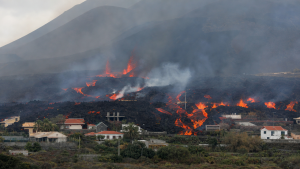
Volcanic hazards include direct products of an eruption and secondary events triggered by volcanic activity. Their effects can extend from the volcano’s slopes to distant communities, waterways and air routes, making hazard assessment and timely public-safety measures essential.
Primary Volcanic Hazards
Primary hazards originate directly from an eruption and are often most severe near the vent.
- Lava flows: Streams of molten rock can exceed 1,093°C. They usually move slowly, sometimes only a few metres per hour, allowing time for evacuation. However, they bury, crush and burn buildings, roads, vegetation and other features in their path.
- Pyroclastic density currents (PDCs): These fast-moving, ground-hugging mixtures of hot gases and volcanic material, or tephra, may travel at tens to hundreds of kilometres per hour. Temperatures commonly range from 200°C to 700°C and can reach 1,000°C. Among the deadliest volcanic hazards, PDCs can arise from the collapse of an eruption column or lava dome, or from an explosive lateral blast.
- Ashfall: Volcanic ash consists of rock, mineral and volcanic-glass fragments smaller than 2 mm. It can be carried hundreds or thousands of kilometres. Heavy deposits can collapse roofs, damage machinery, contaminate water supplies and harm crops and livestock.
- Ballistic projectiles: Volcanic bombs are molten or plastic when ejected; blocks are solid rock fragments. They generally fall close to the vent but may travel several kilometres, creating a severe hazard in nearby areas.
Secondary Volcanic Hazards
Secondary hazards are triggered by volcanic activity rather than being direct eruptive products. They may occur during an eruption or persist afterward.
- Lahars: These destructive flows of water and volcanic debris resemble wet concrete. They form when rainfall, snowmelt or water from a crater lake mixes with loose ash and rock. Lahars can rush down river valleys for tens to hundreds of kilometres, bury settlements, destroy structures, block rivers and reshape landscapes.
- Landslides and debris avalanches: Unstable volcanic slopes may collapse following earthquakes, heavy rainfall or magma intrusion. Large avalanches can bury valleys and create dams that block rivers, increasing the risk of flooding.
- Volcanic tsunamis: Submarine eruptions, flank collapses into water, or PDCs and lahars entering the sea can generate tsunamis. Though less common, tsunamis have caused a significant number of fatalities associated with volcanic eruptions.
Volcanic Gases and Their Dangers
Magma releases gases before, during and after eruptions. Water vapour is the most abundant, but other gases can threaten health and the environment.
- Sulfur dioxide (SO2): It can form volcanic smog, or vog, and acid rain. Large explosive eruptions that inject SO2 into the stratosphere can contribute to global cooling and ozone depletion.
- Carbon dioxide (CO2): Denser than air, it can collect in low-lying areas, displace oxygen and cause asphyxiation. A CO2 release at Lake Nyos, Cameroon, caused mass fatalities in 1986.
- Hydrogen fluoride (HF): HF can condense on ash particles. Animals that eat contaminated vegetation may be poisoned and develop fluorosis.
- Hydrogen chloride (HCl): It can form acid aerosols and irritate mucous membranes and the respiratory tract.
Monitoring and Alert Systems
Volcano monitoring looks for changes that may indicate unrest or an approaching eruption. No single observation captures every hazard, so several methods are used.
- Seismic monitoring: Earthquakes and volcanic tremor are recorded and analysed to identify changes in volcanic activity.
- Ground deformation: Changes in a volcano’s shape or elevation can be measured using tiltmeters, GPS and satellite remote sensing such as InSAR.
- Gas emissions: Changes in the composition and flux of volcanic gases can indicate shifts in magma depth or activity.
- Thermal monitoring: Surface-temperature changes are observed as another indicator of volcanic activity.
- Alert systems: Volcano Alert Level Systems communicate ground hazards using ranked levels, while aviation colour codes communicate ash-related risks to aircraft. Ground alert levels commonly range from Normal to Warning; aviation codes run from Green through Yellow and Orange to Red. The systems are distinct but complementary.
Impacts and Public Safety
The severity of impacts depends on the hazard, its reach and the exposure of people and infrastructure. Hazard assessment supports warnings, evacuation decisions and measures to reduce harm.
- People and health: PDCs, ballistic projectiles and lahars can cause immediate fatalities. Ash and gases can cause respiratory problems and eye irritation; prolonged exposure may contribute to bronchitis and lung disease.
- Infrastructure: Lava can bury buildings and roads. Ash may collapse roofs, disrupt power and communications, damage machinery and contaminate water. Lahars can destroy structures along river valleys.
- Agriculture and environment: Ash can smother crops, harm livestock and contaminate water sources. Acid rain can damage vegetation and pollute water bodies. Large eruptions may cause short-term climate cooling, with consequences for crops and food supplies.
- Aviation: Ash can abrade aircraft components, scratch cockpit windows, reduce visibility and clog fuel and water systems. In jet engines, ash may melt and then solidify on turbine blades, causing engine failure and flight disruption.
Key Prelims Takeaways
- Primary hazards include lava flows, PDCs, ashfall and ballistic projectiles; secondary hazards include lahars, landslides and tsunamis.
- PDCs are hot, fast-moving mixtures of gas and tephra; lahars are water mixed with volcanic debris.
- CO2 can cause asphyxiation in low-lying areas, while SO2 can contribute to acid rain and climate effects.
- Seismicity, ground deformation, gas emissions and thermal changes are key monitoring indicators.
- Volcano alert levels address ground hazards; aviation colour codes address volcanic-ash risks to aircraft.
- Effective hazard assessment and timely warnings support evacuation and public safety.
Recent Context
On October 30, 2026, Mayon Volcano in the Philippines produced a 3,000-metre ash plume, and PHIVOLCS raised its alert level from 2 to 3. It recommended evacuation from the six-kilometre Permanent Danger Zone; ash emission continued on October 31, prompting aviation warnings.
| Related | |
|---|---|