Disaster Management in Volcanic Regions
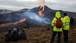
Volcanic disaster management combines hazard assessment, risk reduction, community preparedness, emergency response and recovery. Because eruptions can produce several hazards at once, monitoring and clear evacuation arrangements are essential to protect lives and limit damage.
Understanding Volcanic Hazards
The type and reach of hazards depend on a volcano’s characteristics and eruptive activity. Risk assessment must consider threats on the slopes, along river valleys and, in some cases, beyond the coast.
- Lava flows: Streams of molten rock that typically move more slowly than other volcanic hazards but can destroy buildings, crops and infrastructure in their path.
- Pyroclastic density currents (PDCs): Fast-moving, extremely hot mixtures of gas and volcanic debris. They can travel at hundreds of kilometres per hour and are among the most dangerous eruption hazards.
- Ashfall and volcanic gases: Ash consists of fine rock, mineral and volcanic-glass particles. It can reduce visibility, contaminate water, damage crops, disrupt air travel and cause respiratory risks. Sulfur dioxide (SO₂), carbon dioxide (CO₂) and hydrogen sulfide (H₂S) can be toxic; volcanic gases may also contribute to acid rain and atmospheric changes.
- Lahars, projectiles and other hazards: Lahars are flows of volcanic debris and water, sometimes triggered by rainfall or glacial melt, that can move rapidly down river valleys. Ballistic projectiles can injure people and damage property several kilometres from a volcano. Landslides and debris avalanches may follow seismic activity or structural changes, while submarine eruptions or large landslides entering the sea can generate tsunamis.
Stages of Volcanic Disaster Management
Disaster risk reduction applies throughout the management cycle: mitigation reduces exposure, preparedness enables timely action, response addresses immediate danger, and recovery supports the restoration of communities and services.
- Mitigation: Use hazard maps to identify areas exposed to lava flows, ashfall and lahars. Land-use planning can restrict development in high-risk areas, including Permanent Danger Zones (PDZs). Barriers or channels may be used to deflect lava or redirect lahars, although such structural measures can be difficult and costly. Public awareness helps residents understand local hazards and safety measures.
- Preparedness: Develop evacuation plans with clear triggers, routes, shelters and transport arrangements. Stock emergency supplies, including food, water, medical aid and temporary shelter. Regular drills help residents and emergency personnel practise procedures, while reliable communication channels support the timely distribution of alerts and instructions.
- Response: Monitoring information and alert levels guide pre-planned actions. These can include evacuating danger zones, conducting search and rescue, providing emergency medical care and managing temporary shelters. Rapid assessment of infrastructure and environmental damage helps identify immediate needs.
- Recovery: Rehabilitation restores essential services such as water, electricity and transport. Reconstruction repairs homes and infrastructure, while livelihood support helps communities resume economic activity. Psychosocial support and environmental remediation, including ash removal and agricultural recovery, address longer-term impacts.
Volcanic Monitoring and Early Warning
Monitoring tracks changes that may signal volcanic activity and informs warnings; it does not remove the need for evacuation planning. Volcanological agencies use multiple observations because no single indicator provides a complete picture.
- Seismicity: Seismometers detect earthquakes that may precede or accompany eruptions as magma moves beneath the surface.
- Ground deformation: GPS, tiltmeters and satellite-based interferometric synthetic aperture radar (InSAR) can track changes in a volcano’s shape, including inflation or deflation.
- Gas emissions: Measuring gases such as SO₂ and CO₂ helps identify changes that may indicate magma ascent.
- Thermal and hydrological changes: Infrared cameras and satellite sensors detect temperature changes. Monitoring springs, groundwater levels and river chemistry can reveal changes associated with subsurface volcanic activity.
- Alert levels: Agencies use multi-tiered systems, such as colour-coded or numerical levels, to communicate activity and the likelihood of an eruption. The levels guide response actions, including evacuation.
Evacuation, Response and Local Governance
Evacuation planning links scientific warnings to action on the ground. Disaster risk reduction depends on clear roles, trusted communication and arrangements that residents can follow under pressure.
- Danger zones: PDZs identify areas where the risk is high enough to restrict permanent habitation. Their boundaries should inform land-use planning and evacuation arrangements.
- Contingency plans: Plans should specify evacuation triggers, routes and safe reception centres. Routes and transport arrangements should be communicated in advance and practised through drills.
- Public communication: Authorities need to provide consistent, timely information on alert levels, evacuation orders and safety instructions through available channels.
- Community participation: Involving residents in planning and exercises can improve understanding of local risks and evacuation procedures.
- Coordination: National and local disaster management agencies, scientific institutions, law enforcement and the military need to coordinate their roles. Civil aviation authorities may issue NOTAMs (Notices to Airmen) restricting flights near erupting volcanoes to reduce exposure to ash plumes.
Key Prelims Takeaways
- Major volcanic hazards include lava flows, PDCs, ashfall, lahars, gases, ballistic projectiles, landslides and tsunamis.
- Lahars are flows of volcanic material and water; rainfall or glacial melt can trigger them.
- The disaster management cycle comprises mitigation, preparedness, response and recovery.
- Monitoring covers seismicity, ground deformation, gas emissions, thermal changes and hydrological conditions.
- Alert levels communicate volcanic activity and help guide response actions, including evacuation.
- PDZs restrict permanent habitation in areas of continuing high risk.
Recent Context
On 30 October 2026, Mayon’s 11:53 a.m. moderately explosive eruption lasted nearly six minutes and sent ash 3,000 metres above the crater; a 31 October emission reached 200 metres. PHIVOLCS raised Alert Level 2 to 3, recommended evacuation within the six-kilometre PDZ, and advised aircraft to avoid the summit.
| Related | |
|---|---|