Hurricane Polo Reaches Category 5 off Mexico
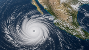
Hurricane Polo intensified to a Category 5 hurricane on 22 September 2026 off Mexico’s Pacific coast. The U.S. National Hurricane Center classified Polo as an extremely dangerous storm with maximum sustained winds of 165 mph to 180 mph, or 265 kph to 290 kph.
Category 5 Hurricane
Category 5 is the highest level on the Saffir-Simpson Hurricane Wind Scale, which classifies hurricanes by sustained wind speed. In the Atlantic and eastern Pacific basins, Category 5 storms have sustained winds of at least 157 mph, or 252 kph.
Location and Track
On 22 September 2026, Polo remained offshore near Zihuatanejo in Guerrero and Manzanillo in Colima. The storm was projected to move towards the southern tip of Mexico’s Baja California Peninsula on 26–27 September 2026.
Warnings, Rainfall and Administrative Measures
Forecasts for 22–24 September 2026 called for 4 to 8 inches of rain in parts of Guerrero and Michoacán. Mexican authorities suspended classes in coastal regions of Guerrero and Michoacán and closed ports to shipping in those states.
Important Facts for Exams
- The U.S. National Hurricane Center is the official agency that monitors tropical cyclones in the Atlantic and eastern Pacific basins.
- The Saffir-Simpson Hurricane Wind Scale has five categories, from Category 1 to Category 5.
- El Niño is a periodic warming of the central and eastern equatorial Pacific Ocean.
- Rapid intensification is a meteorological term used when a tropical cyclone strengthens quickly over a short period.
Pacific Hurricane Season Context
Polo was the third Category 5 hurricane of the 2026 Pacific season, which tied a record. Heavy rainfall from tropical cyclones can trigger flooding and mudslides in mountainous coastal states such as Guerrero and Michoacán.
| Related | |
|---|---|