Cyclone-Prone Coastal Regions of India
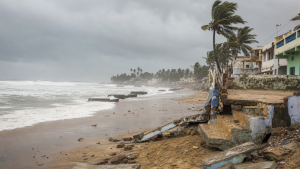
Tropical cyclones threaten India’s coastal regions through destructive winds, heavy rainfall and storm surges. Exposure varies by coastline, population and local conditions, making early warnings, evacuation and region-specific preparedness central to reducing risk.
Tropical Cyclones and IMD Classification
Tropical cyclones form over warm ocean waters, generally where sea-surface temperatures exceed 26.5°C. Their development also depends on favourable atmospheric conditions, including low vertical wind shear. In India, they form mainly over the Bay of Bengal and the Arabian Sea, which together constitute the North Indian Ocean cyclone region. India’s cyclone seasons are generally the pre-monsoon period (April–June) and the post-monsoon period (October–December). The India Meteorological Department (IMD) classifies cyclonic systems by maximum sustained wind speed:
| IMD category | Maximum sustained wind speed |
| Depression | 31–49 kmph |
| Deep Depression | 50–61 kmph |
| Cyclonic Storm | 62–87 kmph |
| Severe Cyclonic Storm | 88–117 kmph |
| Very Severe Cyclonic Storm | 118–166 kmph |
| Extremely Severe Cyclonic Storm | 167–220 kmph |
| Super Cyclonic Storm | Above 220 kmph |
Cyclone-Prone Coastal Regions
India has a coastline of about 7,516 km, and approximately 10% of the world’s tropical cyclones affect the country. The Bay of Bengal generally experiences more frequent and intense cyclones than the Arabian Sea. Warm waters and the region’s geographical configuration contribute to the eastern coast’s exposure, while dense coastal populations can increase the consequences of landfall. East coast and Bay of Bengal: The most vulnerable states and Union Territory include:
- Odisha
- West Bengal
- Andhra Pradesh
- Tamil Nadu
- Puducherry, including Yanam, one of its four districts
West coast and Arabian Sea: Cyclones are less frequent here, but can affect:
- Gujarat
- Maharashtra
- Goa
- Karnataka
- Kerala
- Lakshadweep Islands
The source notes an increasing trend in the frequency and intensity of Arabian Sea cyclones in recent decades, although activity remains lower than in the Bay of Bengal. Regional planning therefore needs to reflect local exposure rather than assume that cyclone risk is confined to the eastern coast. Coastal vulnerability, climate adaptation and regional disaster planning are relevant considerations for reducing risk.
Cyclone Naming and Early Warning
The Regional Specialized Meteorological Centre (RSMC), New Delhi, names tropical cyclones in the North Indian Ocean. It is one of six RSMCs globally. Names are drawn sequentially from a predetermined list submitted by a panel of 13 member countries of the World Meteorological Organization (WMO) and the United Nations Economic and Social Commission for Asia and the Pacific (UNESCAP). The IMD issues forecasts and warnings using satellite imagery, Doppler Weather Radars and automatic weather stations. These sources support monitoring of a storm’s movement and the prediction of landfall. Timely, accessible alerts allow authorities and communities to prepare, including by organising evacuation where required. Warning dissemination is most effective when linked to local response plans and clear instructions.
Disaster Management Framework
The Disaster Management Act, 2005, as amended by the Disaster Management (Amendment) Act, 2025, provides India’s legal framework for disaster management. It establishes institutions for planning and response at national, state and district levels.
- National Disaster Management Authority (NDMA): Headed by the Prime Minister; it lays down disaster-management policies, plans and guidelines.
- National Disaster Response Force (NDRF): Constituted under Section 44 of the Act, it undertakes specialised response operations, including search and rescue during and after cyclones.
- State Disaster Management Authorities (SDMAs): Chaired by the respective Chief Ministers, they coordinate disaster management at state level.
- District Disaster Management Authorities (DDMAs): Chaired by the District Collector, Magistrate or Deputy Commissioner, they manage disaster response at district level.
This framework connects national guidance with state coordination and district-level action. For cyclone-prone areas, effective implementation depends on preparedness plans that account for local hazards and the needs of exposed communities.
Mitigation and Preparedness
Risk reduction combines structural protection with planning, warnings and community readiness. Measures should be adapted to coastal conditions and coordinated across relevant levels of government.
- Structural measures: Cyclone shelters, embankments, sea walls and flood-control systems can help reduce exposure to wind, storm surges and flooding.
- Coastal-zone management: Scientific management of coastal areas supports efforts to address vulnerability to storm surges and coastal erosion.
- Warnings and awareness: Timely dissemination of alerts and community-awareness programmes help people understand the threat and appropriate response.
- Capacity building: Training local communities and preparing disaster-management plans strengthen readiness before landfall.
- Drills and evacuation: Regular mock drills and clear evacuation plans support swift, organised movement when warnings are issued.
These measures are complementary: infrastructure alone cannot replace timely warnings, evacuation arrangements and community preparedness.
Key Prelims Takeaways
- The Bay of Bengal and Arabian Sea are India’s principal cyclone basins; the Bay of Bengal generally has greater cyclone frequency and intensity.
- India’s main cyclone seasons are April–June and October–December.
- A Very Severe Cyclonic Storm has maximum sustained winds of 118–166 kmph.
- RSMC New Delhi names North Indian Ocean cyclones using the prescribed country-submitted list.
- The Disaster Management Act, 2005, as amended in 2025, provides the legal framework for disaster management.
- The NDRF is constituted under Section 44; the NDMA is headed by the Prime Minister.
Recent Context
Cyclone Arnab made landfall near Yanam, between Bapatla and Visakhapatnam, between 2 am and 8 am on October 28, 2026, with winds of 125–135 kmph and gusts up to 150 kmph. It weakened to a severe cyclonic storm by 8:30 am. Evacuations and relief operations were under way; no deaths or major casualties had been reported in Andhra Pradesh or Odisha as of October 28.
| Related | |
|---|---|