Bathinda launches digital navigation pilot covering 2,021 properties in Ward 46
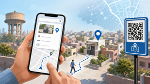
Bathinda Municipal Corporation launched its UnitNav digital navigation pilot in Ward 46 on 3 November 2026. The first phase covers 2,021 properties.
How UnitNav works
Users can enter a property number to view its precise location, distance and direction, as well as a walking route to its gate. UnitNav is available in Punjabi and English through a mobile browser; a separate app download is not required.
Municipal officials also plan to install navigation boards with QR codes at locations across the wards. Scanning a code will direct users to the digital map.
Important Facts for Exams
- Encoded data: QR codes can encode locator, identifier and web-tracking data, whereas ordinary barcodes contain information specific to the labelled item.
- Image detection: QR codes are detected from two-dimensional digital images, rather than by mechanically scanning a one-dimensional barcode with a narrow light beam.
- Mapping and GIS: Computer cartography can operate without a geographic information system; GIS also has functions beyond producing maps.
Originally written on
November 4, 2026
and last modified on
November 4, 2026.
| Related | |
|---|---|