Sentinel-3C Sends First Earth Images After Launch
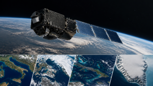
Europe’s Copernicus Sentinel-3C satellite was launched on 15 September 2026 aboard a Vega-C rocket from Europe’s Spaceport in Kourou, French Guiana. In late September, it returned its first images and measurements from two instruments, about two weeks after launch.
Earth Observation Instruments
The Ocean and Land Colour Instrument (OLCI) captured images of Italy, the Canadian Arctic Archipelago and the Caribbean, including Cuba and the Bahamas, on 29 and 30 September 2026. The synthetic aperture radar altimeter began measuring ocean-surface height and the elevation of the Greenland Ice Sheet. Its Greenland observations were taken between 30 September and 4 October.
Sentinel-3 satellites carry instruments for systematic observations of the oceans, land, atmosphere and cryosphere, the frozen parts of the Earth system. Sentinel-3 measurements include sea-surface temperature, ocean colour and height, sea-ice thickness, inland water levels, vegetation conditions and polar ice-sheet elevation.
Copernicus Sentinel-3 Mission
Sentinel-3C is the third spacecraft in the Sentinel-3 series, which forms part of the Copernicus Earth observation programme. The European Space Agency oversees its testing and commissioning, expected to continue for about five months before full operations.
Sentinel-3 data support ocean and weather forecasting and the monitoring of environmental conditions, including marine pollution, droughts and wildfires. Repeated observations of oceans, land and ice also provide measurements used to study long-term environmental changes.
Commissioning and Tandem Operations
During commissioning, Sentinel-3C is planned to operate in tandem with Sentinel-3B for about four months. It is then scheduled to fly in tandem with Sentinel-3A for approximately three months to validate measurements. Initial tests found both instruments performing well.
Important Facts for Exams
- Copernicus is the European Union’s Earth observation programme.
- The cryosphere comprises frozen water on Earth, including glaciers, ice sheets, sea ice and snow.
- A radar altimeter measures the height of the Earth’s surface, including ocean-surface height.
- Vega-C is a European launch vehicle used to carry satellites into orbit.
Sentinel-3C’s first OLCI images were acquired on 29 and 30 September 2026. The European Space Agency is responsible for the satellite’s commissioning.
| Related | |
|---|---|