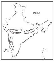
 The places marked A, B, C and D in the map are respectively (UPSC Prelims 1997)
Answer: Rift valley region, Chhattisgarh plain, Chotanagpur plateau and Rain shadow region
Notes: • There is further spreading of crust and subsequent erosion deepens the rift. Rivers that flow thorough rift valley in India are: Narmada River, Tapti, Mahi (all flowing west), and Damodar River in Chota Nagpur plateau.
• Chhattisgarh plain: A vast undulating tract, the plain consists of rich rice fields. Cotton and oilseeds are the important commercial crops of the region. Extensive coal deposits and substantial deposits of iron ore, bauxite, manganese, and commercial clays have aided its development.
• The Chhota Nagpur Plateau is a plateau in eastern India, which covers much of Jharkhand state as well as adjacent parts of Odisha, West Bengal, Bihar and Chhattisgarh. The Indo-Gangetic plain lies to the north and east of the plateau, and the basin of the Mahanadi River lies to the south.
• A rain shadow is a dry area on the leeward side of a mountainous area. The mountains block the passage of rain-producing weather systems and cast a "shadow" of dryness behind them. Eastern Side of Sahyadri ranges on Deccan e.g. Northern Karnataka & Sholapur, Beed, Osmanabad and Vidarbha Plateau of India.
