
Typhoon ‘Mitag’ approaches Northern Taiwan
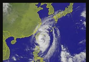
Rapidly-moving Typhoon ‘Mitag’ is bearing down on northern Taiwan, where it is expected to bring high winds and heavy rain. With the worst of the weather expected to arrive in the island country, the warnings have been issued for parts of island’s east and north, including the capital, Taipei.
The Taiwan’s weather bureau has categorized Typhoon Mitag been as at the second-strongest typhoon level.
Key Highlights
Taiwan’s weather bureau reported that Mitag was strengthening gradually as it approach the coast of Yilan county at about 27 kilometers per hour with winds gusting at up to 162 kilometers per hour (100 mph).
The storm’s center is expected to pass just east of the island before heading toward China’s eastern city of Shanghai (on mainland China), then weakening as it moves toward South Korea and Japan.
What are Typhoons?
Typhoon is the regional names for Tropical Cyclones that occurs in Western Pacific and South China Sea i.e. in Philippines islands, eastern China and Japan the tropical cyclones are called typhoons.
A typhoon is a mature tropical cyclone that develops between 180° (or 180th meridian or antimeridian is meridian 180° both east and west of Prime Meridian) and 100°E in the Northern Hemisphere. This region is referred to as Northwestern Pacific Basin which is the most active tropical cyclone basin on Earth. This region accounts for almost one-third (33%) of the world’s annual tropical cyclones.
Related Posts
Month: Current Affairs - October, 2019